Charleston geodata
Charleston (South Carolina) is a seat of a second-order administrative division; located in United States in America/New_York (GMT-4) time zone. With population of 132,609 people, there are 228 cities with bigger population in this country. Compared to other cities in United States, 86% of cities are located further ↑North; 73.6% of cities are located further ←West and 91.5% of cities have higher elevation than Charleston. Note1


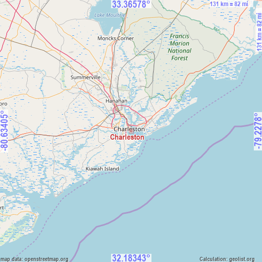
Charleston GPS coordinates[2]
32° 46' 35.652" North, 79° 55' 51.312" West
| Map corner | latitude | longitude |
|---|---|---|
| Upper-left | 33.36578°, | -80.63405° |
| Center: | 32.77657°, | -79.93092° |
| Lower-right: | 32.18343°, | -79.2278° |
| Map W x H: | 131.5×131.5 km | = 81.7×81.7mi |
| max Lat: | 71.29058° ⇑86% North |
| Charleston: | 32.77657° |
| min Lat: | ⇓14% South 19.06759° |
| min Long | Charleston | max Long |
| -171.73463° | -79.93092° | -66.98998° |
| W 73.6%⇐ | ⇒26.4% E |
Elevation
Elevation of Charleston is 13 m = 43 ft, and this is 281.8 m = 925 ft below average elevation for this country.
| Max E: |
3189 m = 10463 ft | 91.5% |
| Avg. | 294.8 m = 967 ft | |
| Charleston | 13 m = 43 ft | |
Min E: |
-60 m = -197 ft | 8.5% |
See also: Charleston elevation on elevation.city.
Geographical zone
Charleston is located in North temperate zone (between Tropic of Cancer and the Arctic Circle). Distance of this Northern Tropic circle is 1038.5 km =645.3 mi to South.| Distance of | km | miles | from Charleston |
|---|---|---|---|
| North Pole | 6362.6 | 3953.5 | to North |
| Arctic Circle | 3756.8 | 2334.4 | to North |
| Tropic Cancer | 1038.5 | 645.3 | to South |
| Equator | 3644.4 | 2264.5 | to South |


Nearby cities:
15 places around Charleston: (largest is in red/bold)
• Folly Beach
13.5 km =8.4 mi,  183°
183°
• Goose Creek
24.6 km =15.3 mi,  337°
337°
• Hanahan
17.9 km =11.1 mi,  331°
331°
• Hollywood
29.4 km =18.3 mi,  260°
260°
• Isle of Palms
12.8 km =8 mi,  84°
84°
• James Island
6.6 km =4.1 mi,  206°
206°
• Kiawah Island
23.6 km =14.7 mi,  217°
217°
• Ladson
28.6 km =17.8 mi,  324°
324°
• Meggett
29.5 km =18.3 mi, 257°
• Mount Pleasant
6.7 km =4.2 mi,  73°
73°
• North Charleston
9.6 km =6 mi, 334°
• Ravenel
29.9 km =18.6 mi,  267°
267°
• Seabrook Island
31.5 km =19.6 mi,  225°
225°
• Shell Point
16.5 km =10.3 mi, 274°
• Sullivans Island
8.9 km =5.5 mi,  99°
99°
Sources, notices
• [Note1] Compared only with cities in United States existing in our database
• [Src1] Map data: © OpenStreetMap contributors (CC-BY-SA)
• [Src2] Other city data from geonames.org with taken over terms of usage.
• [Src3] Geographical zone / Annual Mean Temperature by Robert A. Rohde @ Wikipedia
