James Island geodata
James Island (South Carolina) is a populated place; located in United States in America/New_York (GMT-4) time zone. With population of 6,000 people, there are 6409 cities with bigger population in this country. Compared to other cities in United States, 86.3% of cities are located further ↑North; 73.4% of cities are located further ←West and 98.8% of cities have higher elevation than James Island. Note1


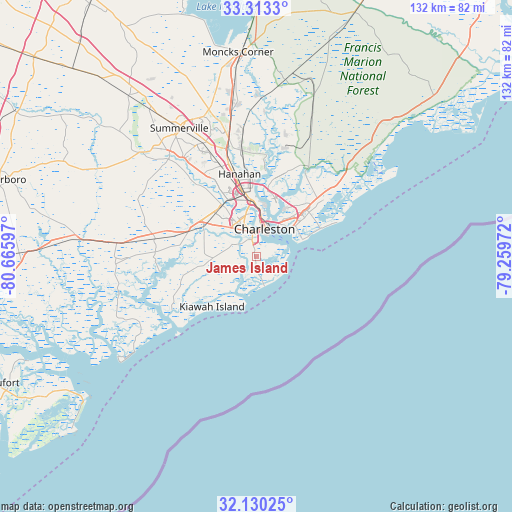
James Island GPS coordinates[2]
32° 43' 25.464" North, 79° 57' 46.224" West
| Map corner | latitude | longitude |
|---|---|---|
| Upper-left | 33.3133°, | -80.66597° |
| Center: | 32.72374°, | -79.96284° |
| Lower-right: | 32.13025°, | -79.25972° |
| Map W x H: | 131.5×131.5 km | = 81.7×81.7mi |
| max Lat: | 71.29058° ⇑86.3% North |
| James Island: | 32.72374° |
| min Lat: | ⇓13.7% South 19.06759° |
| min Long | James Island | max Long |
| -171.73463° | -79.96284° | -66.98998° |
| W 73.4%⇐ | ⇒26.6% E |
Elevation
Elevation of James Island is 4 m = 13 ft, and this is 290.8 m = 954 ft below average elevation for this country.
| Max E: |
3189 m = 10463 ft | 98.8% |
| Avg. | 294.8 m = 967 ft | |
| James Island | 4 m = 13 ft | |
Min E: |
-60 m = -197 ft | 1.2% |
See also: United States elevation on elevation.city.
Geographical zone
James Island is located in North temperate zone (between Tropic of Cancer and the Arctic Circle). Distance of this Northern Tropic circle is 1032.6 km =641.6 mi to South.| Distance of | km | miles | from James Island |
|---|---|---|---|
| North Pole | 6368.5 | 3957.2 | to North |
| Arctic Circle | 3762.6 | 2338 | to North |
| Tropic Cancer | 1032.6 | 641.6 | to South |
| Equator | 3638.5 | 2260.9 | to South |


Nearby cities:
15 places around James Island: (largest is in red/bold)
• Charleston
6.6 km =4.1 mi,  26°
26°
• Folly Beach
7.9 km =4.9 mi,  164°
164°
• Goose Creek
29.3 km =18.2 mi,  347°
347°
• Hanahan
22.4 km =13.9 mi, 345°
• Hollywood
26.1 km =16.2 mi,  272°
272°
• Isle of Palms
17.2 km =10.7 mi,  65°
65°
• Kiawah Island
17.2 km =10.7 mi,  221°
221°
• Ladson
32.2 km =20 mi,  334°
334°
• Meggett
25.8 km =16 mi, 268°
• Mount Pleasant
12.2 km =7.6 mi,  50°
50°
• North Charleston
14.6 km =9.1 mi,  355°
355°
• Ravenel
27.2 km =16.9 mi,  279°
279°
• Seabrook Island
25.4 km =15.8 mi,  230°
230°
• Shell Point
15.3 km =9.5 mi,  298°
298°
• Sullivans Island
12.6 km =7.8 mi, 69°
Sources, notices
• [Note1] Compared only with cities in United States existing in our database
• [Src1] Map data: © OpenStreetMap contributors (CC-BY-SA)
• [Src2] Other city data from geonames.org with taken over terms of usage.
• [Src3] Geographical zone / Annual Mean Temperature by Robert A. Rohde @ Wikipedia
