Society Hill geodata
Society Hill (South Carolina) is a populated place; located in United States in America/New_York (GMT-4) time zone. With population of 548 people, there are 20295 cities with bigger population in this country. Compared to other cities in United States, 77.6% of cities are located further ↑North; 74% of cities are located further ←West and 78.8% of cities have higher elevation than Society Hill. Note1


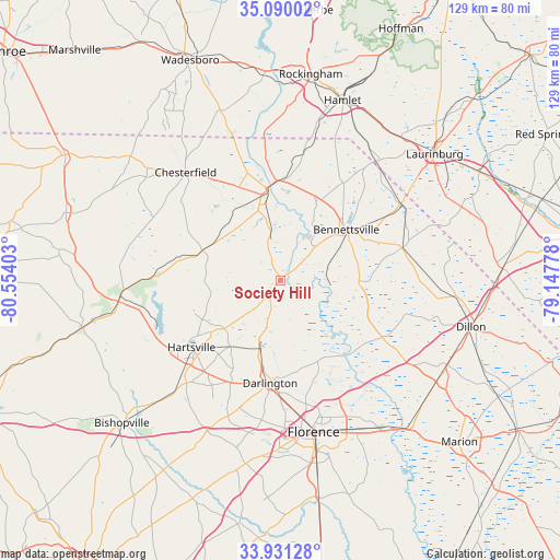
Society Hill GPS coordinates[2]
34° 30' 45.576" North, 79° 51' 3.24" West
| Map corner | latitude | longitude |
|---|---|---|
| Upper-left | 35.09002°, | -80.55403° |
| Center: | 34.51266°, | -79.8509° |
| Lower-right: | 33.93128°, | -79.14778° |
| Map W x H: | 128.8×128.8 km | = 80×80mi |
| max Lat: | 71.29058° ⇑77.6% North |
| Society Hill: | 34.51266° |
| min Lat: | ⇓22.4% South 19.06759° |
| min Long | Society Hill | max Long |
| -171.73463° | -79.8509° | -66.98998° |
| W 74%⇐ | ⇒26% E |
Elevation
Elevation of Society Hill is 52 m = 171 ft, and this is 242.8 m = 797 ft below average elevation for this country.
| Max E: |
3189 m = 10463 ft | 78.8% |
| Avg. | 294.8 m = 967 ft | |
| Society Hill | 52 m = 171 ft | |
Min E: |
-60 m = -197 ft | 21.2% |
See also: United States elevation on elevation.city.
Geographical zone
Society Hill is located in North temperate zone (between Tropic of Cancer and the Arctic Circle). Distance of this Northern Tropic circle is 1231.5 km =765.2 mi to South.| Distance of | km | miles | from Society Hill |
|---|---|---|---|
| North Pole | 6169.6 | 3833.6 | to North |
| Arctic Circle | 3563.7 | 2214.4 | to North |
| Tropic Cancer | 1231.5 | 765.2 | to South |
| Equator | 3837.4 | 2384.4 | to South |


Nearby cities:
15 places around Society Hill: (largest is in red/bold)
• Bennettsville
19.2 km =11.9 mi,  52°
52°
• Cheraw
20.8 km =12.9 mi,  351°
351°
• Chesterfield
33 km =20.5 mi,  318°
318°
• Clio
28.9 km =18 mi,  75°
75°
• Darlington
23.8 km =14.8 mi,  185°
185°
• Florence
36.2 km =22.5 mi,  167°
167°
• Gibson
35.1 km =21.8 mi,  38°
38°
• Hartsville
25.6 km =15.9 mi,  232°
232°
• Lydia
34.5 km =21.4 mi,  223°
223°
• McBee
37.4 km =23.2 mi,  262°
262°
• McColl
32.9 km =20.4 mi,  58°
58°
• North Hartsville
24 km =14.9 mi,  236°
236°
• Quinby
32.5 km =20.2 mi,  160°
160°
• Timmonsville
42.8 km =26.6 mi, 190°
• Wallace
23.1 km =14.4 mi,  2°
2°
Sources, notices
• [Note1] Compared only with cities in United States existing in our database
• [Src1] Map data: © OpenStreetMap contributors (CC-BY-SA)
• [Src2] Other city data from geonames.org with taken over terms of usage.
• [Src3] Geographical zone / Annual Mean Temperature by Robert A. Rohde @ Wikipedia
