Fair Play geodata
Fair Play (South Carolina) is a populated place; located in United States in America/New_York (GMT-4) time zone. With population of 687 people, there are 18811 cities with bigger population in this country. Compared to other cities in United States, 77.6% of cities are located further ↑North; 62% of cities are located further ←West and 61.7% of cities have lower elevation than Fair Play. Note1


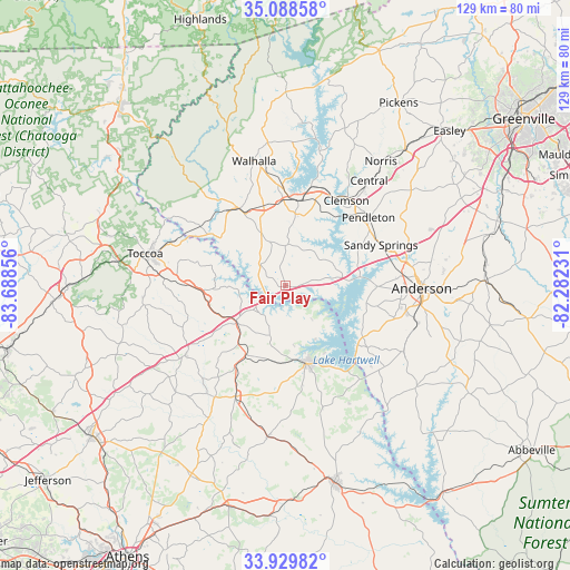
Fair Play GPS coordinates[2]
34° 30' 40.356" North, 82° 59' 7.548" West
| Map corner | latitude | longitude |
|---|---|---|
| Upper-left | 35.08858°, | -83.68856° |
| Center: | 34.51121°, | -82.98543° |
| Lower-right: | 33.92982°, | -82.28231° |
| Map W x H: | 128.8×128.8 km | = 80×80mi |
| max Lat: | 71.29058° ⇑77.6% North |
| Fair Play: | 34.51121° |
| min Lat: | ⇓22.4% South 19.06759° |
| min Long | Fair Play | max Long |
| -171.73463° | -82.98543° | -66.98998° |
| W 62%⇐ | ⇒38% E |
Elevation
Elevation of Fair Play is 247 m = 810 ft, and this is 47.8 m = 157 ft below average elevation for this country.
| Max E: |
3189 m = 10463 ft | 38.3% |
| Avg. | 294.8 m = 967 ft | |
| Fair Play | 247 m = 810 ft | |
Min E: |
-60 m = -197 ft | 61.7% |
See also: United States elevation on elevation.city.
Geographical zone
Fair Play is located in North temperate zone (between Tropic of Cancer and the Arctic Circle). Distance of this Northern Tropic circle is 1231.4 km =765.2 mi to South.| Distance of | km | miles | from Fair Play |
|---|---|---|---|
| North Pole | 6169.8 | 3833.7 | to North |
| Arctic Circle | 3563.9 | 2214.5 | to North |
| Tropic Cancer | 1231.4 | 765.2 | to South |
| Equator | 3837.3 | 2384.4 | to South |


Nearby cities:
15 places around Fair Play: (largest is in red/bold)
• Canon
21.6 km =13.4 mi,  211°
211°
• Carnesville
27.8 km =17.3 mi,  235°
235°
• Centerville
25.9 km =16.1 mi,  84°
84°
• Clemson
23.5 km =14.6 mi,  35°
35°
• Franklin Springs
29.1 km =18.1 mi, 210°
• Gumlog
10.4 km =6.5 mi,  258°
258°
• Hartwell
18.3 km =11.4 mi,  164°
164°
• Lavonia
13.9 km =8.6 mi,  233°
233°
• Northlake
28.3 km =17.6 mi, 77°
• Pendleton
24.2 km =15 mi,  49°
49°
• Reed Creek
9.1 km =5.7 mi,  142°
142°
• Royston
27.4 km =17 mi,  204°
204°
• Seneca
19.6 km =12.2 mi,  8°
8°
• Utica
19.2 km =11.9 mi, 14°
• Westminster
19.9 km =12.4 mi,  329°
329°
Sources, notices
• [Note1] Compared only with cities in United States existing in our database
• [Src1] Map data: © OpenStreetMap contributors (CC-BY-SA)
• [Src2] Other city data from geonames.org with taken over terms of usage.
• [Src3] Geographical zone / Annual Mean Temperature by Robert A. Rohde @ Wikipedia
