Carnesville geodata
Carnesville (Georgia) is a seat of a second-order administrative division; located in United States in America/New_York (GMT-4) time zone. With population of 580 people, there are 19917 cities with bigger population in this country. Compared to other cities in United States, 78.2% of cities are located further ↑North; 61.3% of cities are located further ←West and 56.1% of cities have lower elevation than Carnesville. Note1


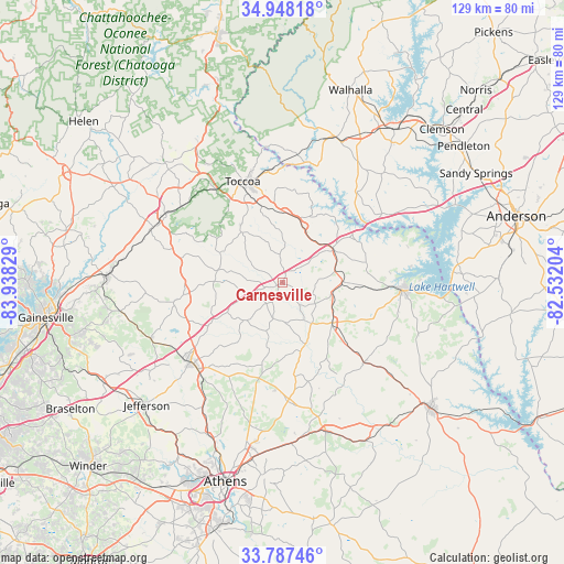
Carnesville GPS coordinates[2]
34° 22' 11.388" North, 83° 14' 6.576" West
| Map corner | latitude | longitude |
|---|---|---|
| Upper-left | 34.94818°, | -83.93829° |
| Center: | 34.36983°, | -83.23516° |
| Lower-right: | 33.78746°, | -82.53204° |
| Map W x H: | 129.1×129.1 km | = 80.2×80.2mi |
| max Lat: | 71.29058° ⇑78.2% North |
| Carnesville: | 34.36983° |
| min Lat: | ⇓21.8% South 19.06759° |
| min Long | Carnesville | max Long |
| -171.73463° | -83.23516° | -66.98998° |
| W 61.3%⇐ | ⇒38.7% E |
Elevation
Elevation of Carnesville is 223 m = 732 ft, and this is 71.8 m = 236 ft below average elevation for this country.
| Max E: |
3189 m = 10463 ft | 43.9% |
| Avg. | 294.8 m = 967 ft | |
| Carnesville | 223 m = 732 ft | |
Min E: |
-60 m = -197 ft | 56.1% |
See also: United States elevation on elevation.city.
Geographical zone
Carnesville is located in North temperate zone (between Tropic of Cancer and the Arctic Circle). Distance of this Northern Tropic circle is 1215.6 km =755.3 mi to South.| Distance of | km | miles | from Carnesville |
|---|---|---|---|
| North Pole | 6185.5 | 3843.5 | to North |
| Arctic Circle | 3579.6 | 2224.3 | to North |
| Tropic Cancer | 1215.6 | 755.3 | to South |
| Equator | 3821.6 | 2374.6 | to South |


Nearby cities:
15 places around Carnesville: (largest is in red/bold)
• Baldwin
30.9 km =19.2 mi,  296°
296°
• Bowman
26.3 km =16.3 mi,  134°
134°
• Canon
11.8 km =7.3 mi,  102°
102°
• Commerce
27.5 km =17.1 mi,  227°
227°
• Danielsville
27.3 km =17 mi,  177°
177°
• Fair Play
27.8 km =17.3 mi,  55°
55°
• Franklin Springs
12.6 km =7.8 mi,  138°
138°
• Gumlog
18.6 km =11.6 mi,  43°
43°
• Hartwell
27.9 km =17.3 mi,  93°
93°
• Homer
24.6 km =15.3 mi,  260°
260°
• Lavonia
13.9 km =8.6 mi, 58°
• Mount Airy
29.4 km =18.3 mi, 304°
• Reed Creek
29.7 km =18.5 mi,  73°
73°
• Royston
14.7 km =9.1 mi, 128°
• Toccoa
24.7 km =15.3 mi,  338°
338°
Sources, notices
• [Note1] Compared only with cities in United States existing in our database
• [Src1] Map data: © OpenStreetMap contributors (CC-BY-SA)
• [Src2] Other city data from geonames.org with taken over terms of usage.
• [Src3] Geographical zone / Annual Mean Temperature by Robert A. Rohde @ Wikipedia
