Summerville geodata
Summerville (South Carolina) is a populated place; located in United States in America/New_York (GMT-4) time zone. With population of 48,848 people, there are 981 cities with bigger population in this country. Compared to other cities in United States, 85.1% of cities are located further ↑North; 72.4% of cities are located further ←West and 86.2% of cities have higher elevation than Summerville. Note1


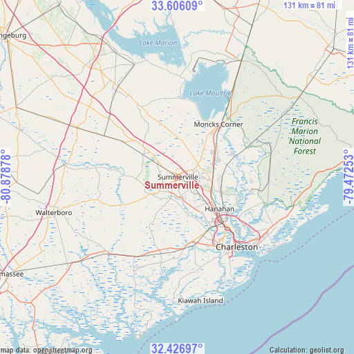
Summerville GPS coordinates[2]
33° 1' 6.6" North, 80° 10' 32.34" West
| Map corner | latitude | longitude |
|---|---|---|
| Upper-left | 33.60609°, | -80.87878° |
| Center: | 33.0185°, | -80.17565° |
| Lower-right: | 32.42697°, | -79.47253° |
| Map W x H: | 131.1×131.1 km | = 81.5×81.5mi |
| max Lat: | 71.29058° ⇑85.1% North |
| Summerville: | 33.0185° |
| min Lat: | ⇓14.9% South 19.06759° |
| min Long | Summerville | max Long |
| -171.73463° | -80.17565° | -66.98998° |
| W 72.4%⇐ | ⇒27.6% E |
Elevation
Elevation of Summerville is 25 m = 82 ft, and this is 269.8 m = 885 ft below average elevation for this country.
| Max E: |
3189 m = 10463 ft | 86.2% |
| Avg. | 294.8 m = 967 ft | |
| Summerville | 25 m = 82 ft | |
Min E: |
-60 m = -197 ft | 13.8% |
See also: Summerville elevation on elevation.city.
Geographical zone
Summerville is located in North temperate zone (between Tropic of Cancer and the Arctic Circle). Distance of this Northern Tropic circle is 1065.4 km =662 mi to South.| Distance of | km | miles | from Summerville |
|---|---|---|---|
| North Pole | 6335.7 | 3936.8 | to North |
| Arctic Circle | 3729.9 | 2317.7 | to North |
| Tropic Cancer | 1065.4 | 662 | to South |
| Equator | 3671.3 | 2281.2 | to South |


Nearby cities:
15 places around Summerville: (largest is in red/bold)
• Centerville
2.6 km =1.6 mi,  168°
168°
• Cottageville
29.9 km =18.6 mi,  252°
252°
• Goose Creek
14 km =8.7 mi,  107°
107°
• Hanahan
18.1 km =11.2 mi,  127°
127°
• Harleyville
33.4 km =20.8 mi,  310°
310°
• Hollywood
32.2 km =20 mi,  191°
191°
• Ladson
7.1 km =4.4 mi,  120°
120°
• Lincolnville
2.3 km =1.4 mi, 124°
• Moncks Corner
24.8 km =15.4 mi,  37°
37°
• North Charleston
26.1 km =16.2 mi, 134°
• Pinopolis
26.5 km =16.5 mi,  29°
29°
• Ravenel
29.2 km =18.1 mi, 193°
• Ridgeville
15.6 km =9.7 mi,  303°
303°
• Sangaree
4.8 km =3 mi,  67°
67°
• Shell Point
26.3 km =16.3 mi, 165°
Sources, notices
• [Note1] Compared only with cities in United States existing in our database
• [Src1] Map data: © OpenStreetMap contributors (CC-BY-SA)
• [Src2] Other city data from geonames.org with taken over terms of usage.
• [Src3] Geographical zone / Annual Mean Temperature by Robert A. Rohde @ Wikipedia
