Iva geodata
Iva (South Carolina) is a populated place; located in United States in America/New_York (GMT-4) time zone. With population of 1,278 people, there are 14692 cities with bigger population in this country. Compared to other cities in United States, 78.4% of cities are located further ↑North; 63.1% of cities are located further ←West and 55.6% of cities have lower elevation than Iva. Note1


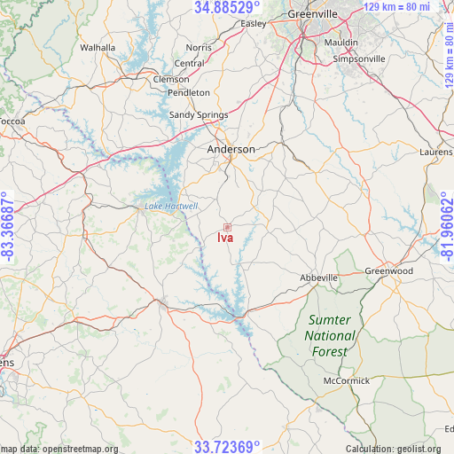
Iva GPS coordinates[2]
34° 18' 23.4" North, 82° 39' 49.464" West
| Map corner | latitude | longitude |
|---|---|---|
| Upper-left | 34.88529°, | -83.36687° |
| Center: | 34.3065°, | -82.66374° |
| Lower-right: | 33.72369°, | -81.96062° |
| Map W x H: | 129.2×129.2 km | = 80.3×80.3mi |
| max Lat: | 71.29058° ⇑78.4% North |
| Iva: | 34.3065° |
| min Lat: | ⇓21.6% South 19.06759° |
| min Long | Iva | max Long |
| -171.73463° | -82.66374° | -66.98998° |
| W 63.1%⇐ | ⇒36.9% E |
Elevation
Elevation of Iva is 221 m = 725 ft, and this is 73.8 m = 242 ft below average elevation for this country.
| Max E: |
3189 m = 10463 ft | 44.4% |
| Avg. | 294.8 m = 967 ft | |
| Iva | 221 m = 725 ft | |
Min E: |
-60 m = -197 ft | 55.6% |
See also: United States elevation on elevation.city.
Geographical zone
Iva is located in North temperate zone (between Tropic of Cancer and the Arctic Circle). Distance of this Northern Tropic circle is 1208.6 km =751 mi to South.| Distance of | km | miles | from Iva |
|---|---|---|---|
| North Pole | 6192.5 | 3847.8 | to North |
| Arctic Circle | 3586.6 | 2228.6 | to North |
| Tropic Cancer | 1208.6 | 751 | to South |
| Equator | 3814.5 | 2370.2 | to South |


Nearby cities:
15 places around Iva: (largest is in red/bold)
• Abbeville
29.8 km =18.5 mi,  118°
118°
• Anderson
21.9 km =13.6 mi,  3°
3°
• Belton
28.6 km =17.8 mi,  32°
32°
• Bowman
35.6 km =22.1 mi,  251°
251°
• Calhoun Falls
24.6 km =15.3 mi,  165°
165°
• Centerville
25.3 km =15.7 mi,  351°
351°
• Due West
25.5 km =15.8 mi,  83°
83°
• Elberton
28.7 km =17.8 mi,  221°
221°
• Fair Play
37.3 km =23.2 mi,  307°
307°
• Hartwell
25.2 km =15.7 mi,  281°
281°
• Homeland Park
18.3 km =11.4 mi,  357°
357°
• Honea Path
29.4 km =18.3 mi,  58°
58°
• Lake Secession
6.8 km =4.2 mi,  111°
111°
• Northlake
28.9 km =18 mi, 356°
• Reed Creek
28.5 km =17.7 mi,  302°
302°
Sources, notices
• [Note1] Compared only with cities in United States existing in our database
• [Src1] Map data: © OpenStreetMap contributors (CC-BY-SA)
• [Src2] Other city data from geonames.org with taken over terms of usage.
• [Src3] Geographical zone / Annual Mean Temperature by Robert A. Rohde @ Wikipedia
