Homeland Park geodata
Homeland Park (South Carolina) is a populated place; located in United States in America/New_York (GMT-4) time zone. With population of 6,296 people, there are 6223 cities with bigger population in this country. Compared to other cities in United States, 77.8% of cities are located further ↑North; 63.1% of cities are located further ←West and 60.3% of cities have lower elevation than Homeland Park. Note1


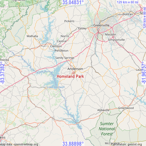
Homeland Park GPS coordinates[2]
34° 28' 14.376" North, 82° 40' 14.484" West
| Map corner | latitude | longitude |
|---|---|---|
| Upper-left | 35.04831°, | -83.37382° |
| Center: | 34.47066°, | -82.67069° |
| Lower-right: | 33.88898°, | -81.96757° |
| Map W x H: | 128.9×128.9 km | = 80.1×80.1mi |
| max Lat: | 71.29058° ⇑77.8% North |
| Homeland Park: | 34.47066° |
| min Lat: | ⇓22.2% South 19.06759° |
| min Long | Homeland Park | max Long |
| -171.73463° | -82.67069° | -66.98998° |
| W 63.1%⇐ | ⇒36.9% E |
Elevation
Elevation of Homeland Park is 241 m = 791 ft, and this is 53.8 m = 177 ft below average elevation for this country.
| Max E: |
3189 m = 10463 ft | 39.7% |
| Avg. | 294.8 m = 967 ft | |
| Homeland Park | 241 m = 791 ft | |
Min E: |
-60 m = -197 ft | 60.3% |
See also: United States elevation on elevation.city.
Geographical zone
Homeland Park is located in North temperate zone (between Tropic of Cancer and the Arctic Circle). Distance of this Northern Tropic circle is 1226.9 km =762.4 mi to South.| Distance of | km | miles | from Homeland Park |
|---|---|---|---|
| North Pole | 6174.3 | 3836.5 | to North |
| Arctic Circle | 3568.4 | 2217.3 | to North |
| Tropic Cancer | 1226.9 | 762.4 | to South |
| Equator | 3832.8 | 2381.6 | to South |


Nearby cities:
15 places around Homeland Park: (largest is in red/bold)
• Anderson
4.1 km =2.5 mi,  27°
27°
• Belton
17.2 km =10.7 mi,  70°
70°
• Centerville
7.5 km =4.7 mi,  335°
335°
• Central
30 km =18.6 mi, 340°
• Clemson
28.2 km =17.5 mi,  327°
327°
• Fair Play
29.2 km =18.1 mi,  278°
278°
• Hartwell
27.3 km =17 mi,  241°
241°
• Honea Path
25.7 km =16 mi,  95°
95°
• Iva
18.3 km =11.4 mi,  177°
177°
• Lake Secession
21.8 km =13.5 mi,  161°
161°
• Northlake
10.7 km =6.6 mi,  353°
353°
• Pendleton
22.6 km =14 mi, 332°
• Reed Creek
23.5 km =14.6 mi,  263°
263°
• West Pelzer
26.7 km =16.6 mi,  43°
43°
• Williamston
24.1 km =15 mi,  47°
47°
Sources, notices
• [Note1] Compared only with cities in United States existing in our database
• [Src1] Map data: © OpenStreetMap contributors (CC-BY-SA)
• [Src2] Other city data from geonames.org with taken over terms of usage.
• [Src3] Geographical zone / Annual Mean Temperature by Robert A. Rohde @ Wikipedia
