Kershaw geodata
Kershaw (South Carolina) is a populated place; located in United States in America/New_York (GMT-4) time zone. With population of 2,052 people, there are 11782 cities with bigger population in this country. Compared to other cities in United States, 77.4% of cities are located further ↑North; 70.6% of cities are located further ←West and 59.1% of cities have higher elevation than Kershaw. Note1


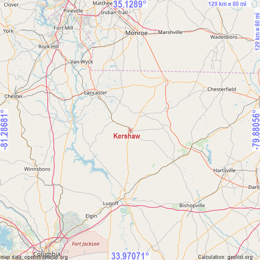
Kershaw GPS coordinates[2]
34° 33' 6.552" North, 80° 35' 1.248" West
| Map corner | latitude | longitude |
|---|---|---|
| Upper-left | 35.1289°, | -81.28681° |
| Center: | 34.55182°, | -80.58368° |
| Lower-right: | 33.97071°, | -79.88056° |
| Map W x H: | 128.8×128.8 km | = 80×80mi |
| max Lat: | 71.29058° ⇑77.4% North |
| Kershaw: | 34.55182° |
| min Lat: | ⇓22.6% South 19.06759° |
| min Long | Kershaw | max Long |
| -171.73463° | -80.58368° | -66.98998° |
| W 70.6%⇐ | ⇒29.4% E |
Elevation
Elevation of Kershaw is 159 m = 522 ft, and this is 135.8 m = 446 ft below average elevation for this country.
| Max E: |
3189 m = 10463 ft | 59.1% |
| Avg. | 294.8 m = 967 ft | |
| Kershaw | 159 m = 522 ft | |
Min E: |
-60 m = -197 ft | 40.9% |
See also: United States elevation on elevation.city.
Geographical zone
Kershaw is located in North temperate zone (between Tropic of Cancer and the Arctic Circle). Distance of this Northern Tropic circle is 1235.9 km =768 mi to South.| Distance of | km | miles | from Kershaw |
|---|---|---|---|
| North Pole | 6165.3 | 3830.9 | to North |
| Arctic Circle | 3559.4 | 2211.7 | to North |
| Tropic Cancer | 1235.9 | 768 | to South |
| Equator | 3841.8 | 2387.2 | to South |


Nearby cities:
15 places around Kershaw: (largest is in red/bold)
• Camden
34 km =21.1 mi,  183°
183°
• Elgin
18.3 km =11.4 mi,  317°
317°
• Fort Lawn
33 km =20.5 mi,  300°
300°
• Great Falls
29.3 km =18.2 mi,  275°
275°
• Heath Springs
9.6 km =6 mi, 298°
• Irwin
26.9 km =16.7 mi,  305°
305°
• Jaars
37.7 km =23.4 mi,  336°
336°
• Jefferson
20.9 km =13 mi,  58°
58°
• Lancaster
25.4 km =15.8 mi, 317°
• Lancaster Mill
26.1 km =16.2 mi, 312°
• Lugoff
37.4 km =23.2 mi,  195°
195°
• McBee
31.4 km =19.5 mi,  107°
107°
• Mineral Springs
43.6 km =27.1 mi,  349°
349°
• Pageland
30.2 km =18.8 mi,  35°
35°
• Springdale
24 km =14.9 mi, 309°
Sources, notices
• [Note1] Compared only with cities in United States existing in our database
• [Src1] Map data: © OpenStreetMap contributors (CC-BY-SA)
• [Src2] Other city data from geonames.org with taken over terms of usage.
• [Src3] Geographical zone / Annual Mean Temperature by Robert A. Rohde @ Wikipedia
