Red Hill geodata
Red Hill (South Carolina) is a populated place; located in United States in America/New_York (GMT-4) time zone. With population of 13,223 people, there are 3616 cities with bigger population in this country. Compared to other cities in United States, 80.2% of cities are located further ↑North; 75.3% of cities are located further ←West and 90.5% of cities have higher elevation than Red Hill. Note1


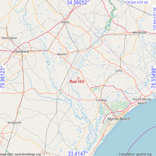
Red Hill GPS coordinates[2]
33° 59' 58.596" North, 79° 15' 29.16" West
| Map corner | latitude | longitude |
|---|---|---|
| Upper-left | 34.58052°, | -79.96123° |
| Center: | 33.99961°, | -79.2581° |
| Lower-right: | 33.4147°, | -78.55498° |
| Map W x H: | 129.6×129.6 km | = 80.5×80.5mi |
| max Lat: | 71.29058° ⇑80.2% North |
| Red Hill: | 33.99961° |
| min Lat: | ⇓19.8% South 19.06759° |
| min Long | Red Hill | max Long |
| -171.73463° | -79.2581° | -66.98998° |
| W 75.3%⇐ | ⇒24.7% E |
Elevation
Elevation of Red Hill is 15 m = 49 ft, and this is 279.8 m = 918 ft below average elevation for this country.
| Max E: |
3189 m = 10463 ft | 90.5% |
| Avg. | 294.8 m = 967 ft | |
| Red Hill | 15 m = 49 ft | |
Min E: |
-60 m = -197 ft | 9.5% |
See also: United States elevation on elevation.city.
Geographical zone
Red Hill is located in North temperate zone (between Tropic of Cancer and the Arctic Circle). Distance of this Northern Tropic circle is 1174.5 km =729.8 mi to South.| Distance of | km | miles | from Red Hill |
|---|---|---|---|
| North Pole | 6226.7 | 3869.1 | to North |
| Arctic Circle | 3620.8 | 2249.9 | to North |
| Tropic Cancer | 1174.5 | 729.8 | to South |
| Equator | 3780.4 | 2349 | to South |


Nearby cities:
15 places around Red Hill: (largest is in red/bold)
• Aynor
5.4 km =3.4 mi,  89°
89°
• Bucksport
39.9 km =24.8 mi,  158°
158°
• Conway
26.6 km =16.5 mi,  133°
133°
• Fair Bluff
40.4 km =25.1 mi,  30°
30°
• Forestbrook
41.4 km =25.7 mi,  138°
138°
• Johnsonville
26.8 km =16.7 mi,  221°
221°
• Lake View
39.4 km =24.5 mi,  12°
12°
• Latta
40.8 km =25.4 mi,  337°
337°
• Loris
34.5 km =21.4 mi,  79°
79°
• Marion
23.8 km =14.8 mi,  326°
326°
• Mullins
22.9 km =14.2 mi,  0°
0°
• Pamplico
28.8 km =17.9 mi,  269°
269°
• Red Hill
29.7 km =18.5 mi, 132°
• Socastee
42.6 km =26.5 mi,  145°
145°
• Tabor City
38.8 km =24.1 mi,  64°
64°
Sources, notices
• [Note1] Compared only with cities in United States existing in our database
• [Src1] Map data: © OpenStreetMap contributors (CC-BY-SA)
• [Src2] Other city data from geonames.org with taken over terms of usage.
• [Src3] Geographical zone / Annual Mean Temperature by Robert A. Rohde @ Wikipedia
