Johnsonville geodata
Johnsonville (South Carolina) is a populated place; located in United States in America/New_York (GMT-4) time zone. With population of 1,504 people, there are 13638 cities with bigger population in this country. Compared to other cities in United States, 81.4% of cities are located further ↑North; 75% of cities are located further ←West and 86.6% of cities have higher elevation than Johnsonville. Note1


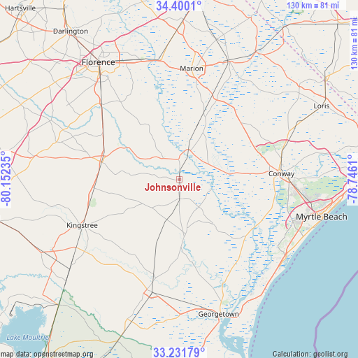
Johnsonville GPS coordinates[2]
33° 49' 4.584" North, 79° 26' 57.192" West
| Map corner | latitude | longitude |
|---|---|---|
| Upper-left | 34.4001°, | -80.15235° |
| Center: | 33.81794°, | -79.44922° |
| Lower-right: | 33.23179°, | -78.7461° |
| Map W x H: | 129.9×129.9 km | = 80.7×80.7mi |
| max Lat: | 71.29058° ⇑81.4% North |
| Johnsonville: | 33.81794° |
| min Lat: | ⇓18.6% South 19.06759° |
| min Long | Johnsonville | max Long |
| -171.73463° | -79.44922° | -66.98998° |
| W 75%⇐ | ⇒25% E |
Elevation
Elevation of Johnsonville is 24 m = 79 ft, and this is 270.8 m = 888 ft below average elevation for this country.
| Max E: |
3189 m = 10463 ft | 86.6% |
| Avg. | 294.8 m = 967 ft | |
| Johnsonville | 24 m = 79 ft | |
Min E: |
-60 m = -197 ft | 13.4% |
See also: United States elevation on elevation.city.
Geographical zone
Johnsonville is located in North temperate zone (between Tropic of Cancer and the Arctic Circle). Distance of this Northern Tropic circle is 1154.3 km =717.2 mi to South.| Distance of | km | miles | from Johnsonville |
|---|---|---|---|
| North Pole | 6246.9 | 3881.6 | to North |
| Arctic Circle | 3641 | 2262.4 | to North |
| Tropic Cancer | 1154.3 | 717.2 | to South |
| Equator | 3760.2 | 2336.5 | to South |


Nearby cities:
15 places around Johnsonville: (largest is in red/bold)
• Andrews
42.1 km =26.2 mi,  194°
194°
• Aynor
30.7 km =19.1 mi,  48°
48°
• Bucksport
36.3 km =22.6 mi,  117°
117°
• Conway
37.1 km =23.1 mi,  86°
86°
• Coward
32.5 km =20.2 mi,  302°
302°
• Forestbrook
46.6 km =29 mi,  103°
103°
• Kingstree
39 km =24.2 mi,  244°
244°
• Lake City
28.9 km =18 mi,  281°
281°
• Marion
40.3 km =25 mi,  6°
6°
• Olanta
46.5 km =28.9 mi,  286°
286°
• Pamplico
22.7 km =14.1 mi,  330°
330°
• Red Hill
26.8 km =16.7 mi,  41°
41°
• Red Hill
39.8 km =24.7 mi, 89°
• Scranton
29.4 km =18.3 mi, 292°
• Socastee
44.3 km =27.5 mi,  109°
109°
Sources, notices
• [Note1] Compared only with cities in United States existing in our database
• [Src1] Map data: © OpenStreetMap contributors (CC-BY-SA)
• [Src2] Other city data from geonames.org with taken over terms of usage.
• [Src3] Geographical zone / Annual Mean Temperature by Robert A. Rohde @ Wikipedia
