Roebuck geodata
Roebuck (South Carolina) is a populated place; located in United States in America/New_York (GMT-4) time zone. With population of 2,200 people, there are 11341 cities with bigger population in this country. Compared to other cities in United States, 76% of cities are located further ↑North; 65.7% of cities are located further ←West and 57.9% of cities have lower elevation than Roebuck. Note1


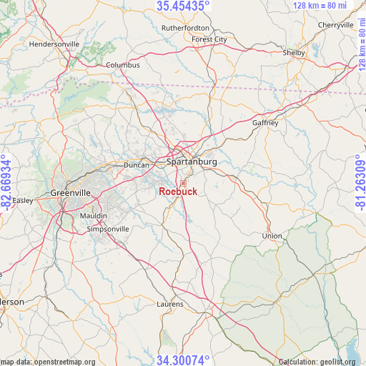
Roebuck GPS coordinates[2]
34° 52' 46.452" North, 81° 57' 58.356" West
| Map corner | latitude | longitude |
|---|---|---|
| Upper-left | 35.45435°, | -82.66934° |
| Center: | 34.87957°, | -81.96621° |
| Lower-right: | 34.30074°, | -81.26309° |
| Map W x H: | 128.3×128.3 km | = 79.7×79.7mi |
| max Lat: | 71.29058° ⇑76% North |
| Roebuck: | 34.87957° |
| min Lat: | ⇓24% South 19.06759° |
| min Long | Roebuck | max Long |
| -171.73463° | -81.96621° | -66.98998° |
| W 65.7%⇐ | ⇒34.3% E |
Elevation
Elevation of Roebuck is 230 m = 755 ft, and this is 64.8 m = 213 ft below average elevation for this country.
| Max E: |
3189 m = 10463 ft | 42.1% |
| Avg. | 294.8 m = 967 ft | |
| Roebuck | 230 m = 755 ft | |
Min E: |
-60 m = -197 ft | 57.9% |
See also: United States elevation on elevation.city.
Geographical zone
Roebuck is located in North temperate zone (between Tropic of Cancer and the Arctic Circle). Distance of this Northern Tropic circle is 1272.3 km =790.6 mi to South.| Distance of | km | miles | from Roebuck |
|---|---|---|---|
| North Pole | 6128.8 | 3808.3 | to North |
| Arctic Circle | 3522.9 | 2189 | to North |
| Tropic Cancer | 1272.3 | 790.6 | to South |
| Equator | 3878.2 | 2409.8 | to South |


Nearby cities:
15 places around Roebuck: (largest is in red/bold)
• Arcadia
9 km =5.6 mi,  345°
345°
• Boiling Springs
18.6 km =11.6 mi,  355°
355°
• Clifton
17.5 km =10.9 mi,  50°
50°
• Converse
17.3 km =10.7 mi,  43°
43°
• Duncan
17.6 km =10.9 mi,  291°
291°
• Fairforest
9.4 km =5.8 mi,  334°
334°
• Lyman
16.6 km =10.3 mi,  297°
297°
• Reidville
13.6 km =8.5 mi,  262°
262°
• Saxon
9.1 km =5.7 mi, 359°
• Southern Shops
12.1 km =7.5 mi, 347°
• Spartanburg
8.4 km =5.2 mi,  21°
21°
• Startex
13.3 km =8.3 mi, 294°
• Valley Falls
15.2 km =9.4 mi, 357°
• Wellford
15 km =9.3 mi, 301°
• Woodruff
16.9 km =10.5 mi,  202°
202°
Sources, notices
• [Note1] Compared only with cities in United States existing in our database
• [Src1] Map data: © OpenStreetMap contributors (CC-BY-SA)
• [Src2] Other city data from geonames.org with taken over terms of usage.
• [Src3] Geographical zone / Annual Mean Temperature by Robert A. Rohde @ Wikipedia
