Spartanburg geodata
Spartanburg (South Carolina) is a seat of a second-order administrative division; located in United States in America/New_York (GMT-4) time zone. With population of 37,867 people, there are 1286 cities with bigger population in this country. Compared to other cities in United States, 75.7% of cities are located further ↑North; 65.8% of cities are located further ←West and 61.9% of cities have lower elevation than Spartanburg. Note1


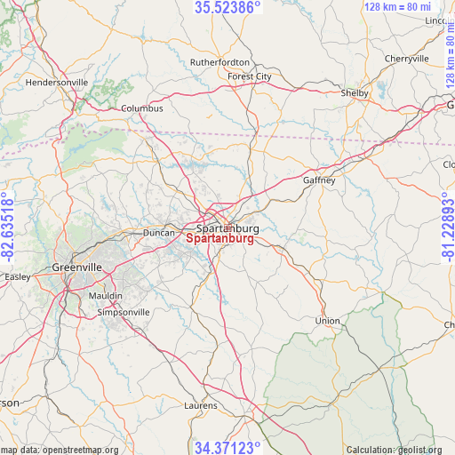
Spartanburg GPS coordinates[2]
34° 56' 58.452" North, 81° 55' 55.38" West
| Map corner | latitude | longitude |
|---|---|---|
| Upper-left | 35.52386°, | -82.63518° |
| Center: | 34.94957°, | -81.93205° |
| Lower-right: | 34.37123°, | -81.22893° |
| Map W x H: | 128.2×128.2 km | = 79.7×79.7mi |
| max Lat: | 71.29058° ⇑75.7% North |
| Spartanburg: | 34.94957° |
| min Lat: | ⇓24.3% South 19.06759° |
| min Long | Spartanburg | max Long |
| -171.73463° | -81.93205° | -66.98998° |
| W 65.8%⇐ | ⇒34.2% E |
Elevation
Elevation of Spartanburg is 248 m = 814 ft, and this is 46.8 m = 154 ft below average elevation for this country.
| Max E: |
3189 m = 10463 ft | 38.1% |
| Avg. | 294.8 m = 967 ft | |
| Spartanburg | 248 m = 814 ft | |
Min E: |
-60 m = -197 ft | 61.9% |
See also: United States elevation on elevation.city.
Geographical zone
Spartanburg is located in North temperate zone (between Tropic of Cancer and the Arctic Circle). Distance of this Northern Tropic circle is 1280.1 km =795.4 mi to South.| Distance of | km | miles | from Spartanburg |
|---|---|---|---|
| North Pole | 6121 | 3803.4 | to North |
| Arctic Circle | 3515.1 | 2184.2 | to North |
| Tropic Cancer | 1280.1 | 795.4 | to South |
| Equator | 3886 | 2414.6 | to South |


Nearby cities:
15 places around Spartanburg: (largest is in red/bold)
• Arcadia
5.4 km =3.4 mi,  280°
280°
• Boiling Springs
11.7 km =7.3 mi,  337°
337°
• Clifton
10.9 km =6.8 mi,  72°
72°
• Converse
10 km =6.2 mi,  61°
61°
• Cowpens
13.9 km =8.6 mi, 57°
• Fairforest
7.2 km =4.5 mi, 276°
• Mayo
16.3 km =10.1 mi,  23°
23°
• Pacolet
16.5 km =10.3 mi,  109°
109°
• Pacolet Mills
17.5 km =10.9 mi,  99°
99°
• Roebuck
8.4 km =5.2 mi,  201°
201°
• Saxon
3.5 km =2.2 mi,  291°
291°
• Southern Shops
7 km =4.3 mi,  305°
305°
• Startex
15.4 km =9.6 mi,  261°
261°
• Valley Falls
8.3 km =5.2 mi,  332°
332°
• Wellford
15.8 km =9.8 mi,  270°
270°
Sources, notices
• [Note1] Compared only with cities in United States existing in our database
• [Src1] Map data: © OpenStreetMap contributors (CC-BY-SA)
• [Src2] Other city data from geonames.org with taken over terms of usage.
• [Src3] Geographical zone / Annual Mean Temperature by Robert A. Rohde @ Wikipedia
