Clifton geodata
Clifton (South Carolina) is a populated place; located in United States in America/New_York (GMT-4) time zone. With population of 541 people, there are 20378 cities with bigger population in this country. Compared to other cities in United States, 75.5% of cities are located further ↑North; 66.2% of cities are located further ←West and 50.3% of cities have higher elevation than Clifton. Note1


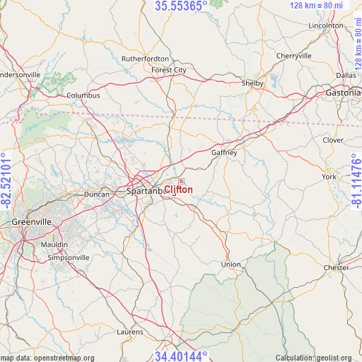
Clifton GPS coordinates[2]
34° 58' 46.452" North, 81° 49' 4.368" West
| Map corner | latitude | longitude |
|---|---|---|
| Upper-left | 35.55365°, | -82.52101° |
| Center: | 34.97957°, | -81.81788° |
| Lower-right: | 34.40144°, | -81.11476° |
| Map W x H: | 128.1×128.1 km | = 79.6×79.6mi |
| max Lat: | 71.29058° ⇑75.5% North |
| Clifton: | 34.97957° |
| min Lat: | ⇓24.5% South 19.06759° |
| min Long | Clifton | max Long |
| -171.73463° | -81.81788° | -66.98998° |
| W 66.2%⇐ | ⇒33.8% E |
Elevation
Elevation of Clifton is 197 m = 646 ft, and this is 97.8 m = 321 ft below average elevation for this country.
| Max E: |
3189 m = 10463 ft | 50.3% |
| Avg. | 294.8 m = 967 ft | |
| Clifton | 197 m = 646 ft | |
Min E: |
-60 m = -197 ft | 49.7% |
See also: United States elevation on elevation.city.
Geographical zone
Clifton is located in North temperate zone (between Tropic of Cancer and the Arctic Circle). Distance of this Northern Tropic circle is 1283.4 km =797.5 mi to South.| Distance of | km | miles | from Clifton |
|---|---|---|---|
| North Pole | 6117.7 | 3801.4 | to North |
| Arctic Circle | 3511.8 | 2182.1 | to North |
| Tropic Cancer | 1283.4 | 797.5 | to South |
| Equator | 3889.4 | 2416.8 | to South |


Nearby cities:
15 places around Clifton: (largest is in red/bold)
• Arcadia
15.9 km =9.9 mi,  261°
261°
• Boiling Springs
16.7 km =10.4 mi,  296°
296°
• Chesnee
19.2 km =11.9 mi,  348°
348°
• Converse
2.1 km =1.3 mi,  311°
311°
• Cowpens
4.3 km =2.7 mi,  16°
16°
• Fairforest
17.7 km =11 mi, 261°
• Gaffney
18.4 km =11.4 mi,  56°
56°
• Mayo
12.2 km =7.6 mi,  341°
341°
• Pacolet
10.3 km =6.4 mi,  150°
150°
• Pacolet Mills
9.3 km =5.8 mi,  132°
132°
• Roebuck
17.5 km =10.9 mi,  230°
230°
• Saxon
13.8 km =8.6 mi, 261°
• Southern Shops
16.1 km =10 mi,  272°
272°
• Spartanburg
10.9 km =6.8 mi,  252°
252°
• Valley Falls
14.9 km =9.3 mi,  285°
285°
Sources, notices
• [Note1] Compared only with cities in United States existing in our database
• [Src1] Map data: © OpenStreetMap contributors (CC-BY-SA)
• [Src2] Other city data from geonames.org with taken over terms of usage.
• [Src3] Geographical zone / Annual Mean Temperature by Robert A. Rohde @ Wikipedia
