Chattanooga geodata
Chattanooga (Tennessee) is a seat of a second-order administrative division; located in United States in America/New_York (GMT-4) time zone. With population of 176,588 people, there are 152 cities with bigger population in this country. Compared to other cities in United States, 75.2% of cities are located further ↑North; 55.1% of cities are located further ←West and 52.5% of cities have lower elevation than Chattanooga. Note1


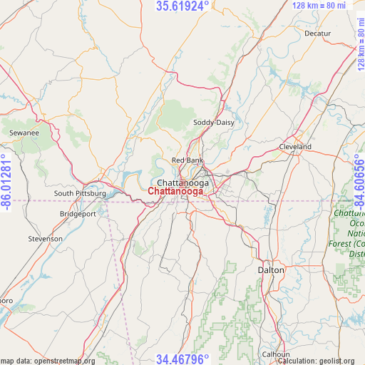
Chattanooga GPS coordinates[2]
35° 2' 44.268" North, 85° 18' 34.848" West
| Map corner | latitude | longitude |
|---|---|---|
| Upper-left | 35.61924°, | -86.01281° |
| Center: | 35.04563°, | -85.30968° |
| Lower-right: | 34.46796°, | -84.60656° |
| Map W x H: | 128×128 km | = 79.5×79.5mi |
| max Lat: | 71.29058° ⇑75.2% North |
| Chattanooga: | 35.04563° |
| min Lat: | ⇓24.8% South 19.06759° |
| min Long | Chattanooga | max Long |
| -171.73463° | -85.30968° | -66.98998° |
| W 55.1%⇐ | ⇒44.9% E |
Elevation
Elevation of Chattanooga is 208 m = 682 ft, and this is 86.8 m = 285 ft below average elevation for this country.
| Max E: |
3189 m = 10463 ft | 47.5% |
| Avg. | 294.8 m = 967 ft | |
| Chattanooga | 208 m = 682 ft | |
Min E: |
-60 m = -197 ft | 52.5% |
See also: Chattanooga elevation on elevation.city.
Geographical zone
Chattanooga is located in North temperate zone (between Tropic of Cancer and the Arctic Circle). Distance of this Northern Tropic circle is 1290.8 km =802.1 mi to South.| Distance of | km | miles | from Chattanooga |
|---|---|---|---|
| North Pole | 6110.4 | 3796.8 | to North |
| Arctic Circle | 3504.5 | 2177.6 | to North |
| Tropic Cancer | 1290.8 | 802.1 | to South |
| Equator | 3896.7 | 2421.3 | to South |


Nearby cities:
15 places around Chattanooga: (largest is in red/bold)
• Chattanooga Valley
13.2 km =8.2 mi,  198°
198°
• East Brainerd
15.5 km =9.6 mi,  110°
110°
• East Chattanooga
5.9 km =3.7 mi,  68°
68°
• East Ridge
6.3 km =3.9 mi,  123°
123°
• Fairmount
15.2 km =9.4 mi,  355°
355°
• Fairview
11.4 km =7.1 mi,  168°
168°
• Fort Oglethorpe
11.8 km =7.3 mi,  155°
155°
• Indian Springs
16.4 km =10.2 mi,  126°
126°
• Lakeview
8.7 km =5.4 mi,  147°
147°
• Lookout Mountain
6.8 km =4.2 mi,  212°
212°
• Lookout Mountain
8.7 km =5.4 mi, 210°
• Red Bank
7.5 km =4.7 mi,  10°
10°
• Rossville
7.3 km =4.5 mi, 162°
• Signal Mountain
9.1 km =5.7 mi,  340°
340°
• Walden
13.3 km =8.3 mi,  3°
3°
Sources, notices
• [Note1] Compared only with cities in United States existing in our database
• [Src1] Map data: © OpenStreetMap contributors (CC-BY-SA)
• [Src2] Other city data from geonames.org with taken over terms of usage.
• [Src3] Geographical zone / Annual Mean Temperature by Robert A. Rohde @ Wikipedia
