East Chattanooga geodata
East Chattanooga (Tennessee) is a populated place; located in United States in America/New_York (GMT-4) time zone. With population of 154,024 people, there are 184 cities with bigger population in this country. Compared to other cities in United States, 75% of cities are located further ↑North; 55.3% of cities are located further ←West and 52.5% of cities have lower elevation than East Chattanooga. Note1


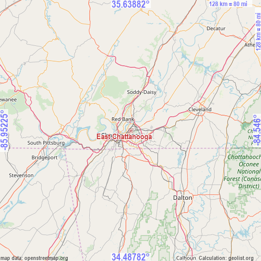
East Chattanooga GPS coordinates[2]
35° 3' 55.26" North, 85° 14' 56.832" West
| Map corner | latitude | longitude |
|---|---|---|
| Upper-left | 35.63882°, | -85.95225° |
| Center: | 35.06535°, | -85.24912° |
| Lower-right: | 34.48782°, | -84.546° |
| Map W x H: | 128×128 km | = 79.5×79.5mi |
| max Lat: | 71.29058° ⇑75% North |
| East Chattanooga: | 35.06535° |
| min Lat: | ⇓25% South 19.06759° |
| min Long | East Chattanoog | max Long |
| -171.73463° | -85.24912° | -66.98998° |
| W 55.3%⇐ | ⇒44.7% E |
Elevation
Elevation of East Chattanooga is 208 m = 682 ft, and this is 86.8 m = 285 ft below average elevation for this country.
| Max E: |
3189 m = 10463 ft | 47.5% |
| Avg. | 294.8 m = 967 ft | |
| East Chattanooga | 208 m = 682 ft | |
Min E: |
-60 m = -197 ft | 52.5% |
See also: East Chattanooga elevation on elevation.city.
Geographical zone
East Chattanooga is located in North temperate zone (between Tropic of Cancer and the Arctic Circle). Distance of this Northern Tropic circle is 1293 km =803.4 mi to South.| Distance of | km | miles | from East Chattanooga |
|---|---|---|---|
| North Pole | 6108.2 | 3795.5 | to North |
| Arctic Circle | 3502.3 | 2176.2 | to North |
| Tropic Cancer | 1293 | 803.4 | to South |
| Equator | 3898.9 | 2422.7 | to South |


Nearby cities:
15 places around East Chattanooga: (largest is in red/bold)
• Chattanooga
5.9 km =3.7 mi,  248°
248°
• East Brainerd
11.9 km =7.4 mi,  130°
130°
• East Ridge
5.7 km =3.5 mi,  182°
182°
• Fairmount
14.6 km =9.1 mi,  332°
332°
• Fairview
13.7 km =8.5 mi,  193°
193°
• Fort Oglethorpe
13 km =8.1 mi, 183°
• Harrison
11.4 km =7.1 mi,  62°
62°
• Indian Springs
14.2 km =8.8 mi,  147°
147°
• Lakeview
9.6 km =6 mi, 185°
• Lookout Mountain
12.1 km =7.5 mi,  229°
229°
• Lookout Mountain
13.9 km =8.6 mi, 225°
• Red Bank
6.6 km =4.1 mi,  321°
321°
• Rossville
9.7 km =6 mi,  200°
200°
• Signal Mountain
10.7 km =6.6 mi,  306°
306°
• Walden
12 km =7.5 mi,  336°
336°
Sources, notices
• [Note1] Compared only with cities in United States existing in our database
• [Src1] Map data: © OpenStreetMap contributors (CC-BY-SA)
• [Src2] Other city data from geonames.org with taken over terms of usage.
• [Src3] Geographical zone / Annual Mean Temperature by Robert A. Rohde @ Wikipedia
