Lookout Mountain geodata
Lookout Mountain (Tennessee) is a populated place; located in United States in America/New_York (GMT-4) time zone. With population of 1,884 people, there are 12265 cities with bigger population in this country. Compared to other cities in United States, 75.4% of cities are located further ↑North; 55% of cities are located further ←West and 89.1% of cities have lower elevation than Lookout Mountain. Note1


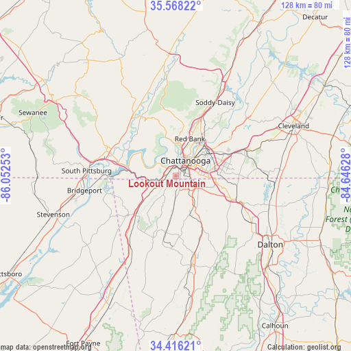
Lookout Mountain GPS coordinates[2]
34° 59' 39.264" North, 85° 20' 57.84" West
| Map corner | latitude | longitude |
|---|---|---|
| Upper-left | 35.56822°, | -86.05253° |
| Center: | 34.99424°, | -85.3494° |
| Lower-right: | 34.41621°, | -84.64628° |
| Map W x H: | 128.1×128.1 km | = 79.6×79.6mi |
| max Lat: | 71.29058° ⇑75.4% North |
| Lookout Mountain: | 34.99424° |
| min Lat: | ⇓24.6% South 19.06759° |
| min Long | Lookout Mountai | max Long |
| -171.73463° | -85.3494° | -66.98998° |
| W 55%⇐ | ⇒45% E |
Elevation
Elevation of Lookout Mountain is 566 m = 1857 ft, and this is 271.2 m = 890 ft above average elevation for this country.
| Max E: |
3189 m = 10463 ft | 10.9% |
| Lookout Mountain | 566 m 1857 ft | |
| Avg. | 294.8 m = 967 ft | |
Min E: |
-60 m = -197 ft | 89.1% |
See also: United States elevation on elevation.city.
Geographical zone
Lookout Mountain is located in North temperate zone (between Tropic of Cancer and the Arctic Circle). Distance of this Northern Tropic circle is 1285.1 km =798.5 mi to South.| Distance of | km | miles | from Lookout Mountain |
|---|---|---|---|
| North Pole | 6116.1 | 3800.4 | to North |
| Arctic Circle | 3510.2 | 2181.1 | to North |
| Tropic Cancer | 1285.1 | 798.5 | to South |
| Equator | 3891 | 2417.8 | to South |


Nearby cities:
15 places around Lookout Mountain: (largest is in red/bold)
• Chattanooga
6.8 km =4.2 mi,  32°
32°
• Chattanooga Valley
6.8 km =4.2 mi,  184°
184°
• Chickamauga
14.7 km =9.1 mi,  158°
158°
• East Brainerd
18.1 km =11.2 mi,  89°
89°
• East Chattanooga
12.1 km =7.5 mi,  49°
49°
• East Ridge
9.2 km =5.7 mi,  75°
75°
• Fairview
8 km =5 mi,  132°
132°
• Fort Oglethorpe
9.8 km =6.1 mi,  120°
120°
• Indian Springs
17.3 km =10.7 mi,  103°
103°
• Lakeview
8.4 km =5.2 mi, 101°
• Lookout Mountain
2 km =1.2 mi,  202°
202°
• Red Bank
14.1 km =8.8 mi,  20°
20°
• Rossville
5.9 km =3.7 mi, 102°
• Signal Mountain
14.3 km =8.9 mi,  2°
2°
• Walden
19.5 km =12.1 mi,  12°
12°
Sources, notices
• [Note1] Compared only with cities in United States existing in our database
• [Src1] Map data: © OpenStreetMap contributors (CC-BY-SA)
• [Src2] Other city data from geonames.org with taken over terms of usage.
• [Src3] Geographical zone / Annual Mean Temperature by Robert A. Rohde @ Wikipedia
