Etowah geodata
Etowah (Tennessee) is a populated place; located in United States in America/New_York (GMT-4) time zone. With population of 3,500 people, there are 8852 cities with bigger population in this country. Compared to other cities in United States, 73.5% of cities are located further ↑North; 57.3% of cities are located further ←West and 61% of cities have lower elevation than Etowah. Note1


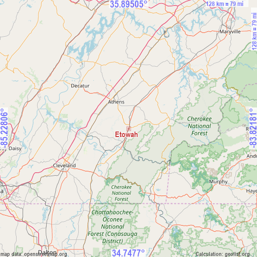
Etowah GPS coordinates[2]
35° 19' 24.276" North, 84° 31' 29.748" West
| Map corner | latitude | longitude |
|---|---|---|
| Upper-left | 35.89505°, | -85.22806° |
| Center: | 35.32341°, | -84.52493° |
| Lower-right: | 34.7477°, | -83.82181° |
| Map W x H: | 127.6×127.6 km | = 79.3×79.3mi |
| max Lat: | 71.29058° ⇑73.5% North |
| Etowah: | 35.32341° |
| min Lat: | ⇓26.5% South 19.06759° |
| min Long | Etowah | max Long |
| -171.73463° | -84.52493° | -66.98998° |
| W 57.3%⇐ | ⇒42.7% E |
Elevation
Elevation of Etowah is 244 m = 801 ft, and this is 50.8 m = 167 ft below average elevation for this country.
| Max E: |
3189 m = 10463 ft | 39% |
| Avg. | 294.8 m = 967 ft | |
| Etowah | 244 m = 801 ft | |
Min E: |
-60 m = -197 ft | 61% |
See also: United States elevation on elevation.city.
Geographical zone
Etowah is located in North temperate zone (between Tropic of Cancer and the Arctic Circle). Distance of this Northern Tropic circle is 1321.7 km =821.3 mi to South.| Distance of | km | miles | from Etowah |
|---|---|---|---|
| North Pole | 6079.5 | 3777.6 | to North |
| Arctic Circle | 3473.6 | 2158.4 | to North |
| Tropic Cancer | 1321.7 | 821.3 | to South |
| Equator | 3927.6 | 2440.5 | to South |


Nearby cities:
15 places around Etowah: (largest is in red/bold)
• Athens
14.6 km =9.1 mi,  335°
335°
• Benton
20.3 km =12.6 mi,  215°
215°
• Charleston
21.6 km =13.4 mi,  259°
259°
• Cleveland
36.8 km =22.9 mi,  240°
240°
• Decatur
32.1 km =19.9 mi,  311°
311°
• East Cleveland
35.2 km =21.9 mi, 239°
• Englewood
11.7 km =7.3 mi,  16°
16°
• Hopewell
34.4 km =21.4 mi,  253°
253°
• Madisonville
26.3 km =16.3 mi,  33°
33°
• Niota
21.2 km =13.2 mi,  355°
355°
• Riceville
16.7 km =10.4 mi,  294°
294°
• South Cleveland
37.5 km =23.3 mi, 237°
• Sweetwater
31.5 km =19.6 mi,  10°
10°
• Tellico Plains
21.4 km =13.3 mi,  78°
78°
• Vonore
39.2 km =24.4 mi,  40°
40°
Sources, notices
• [Note1] Compared only with cities in United States existing in our database
• [Src1] Map data: © OpenStreetMap contributors (CC-BY-SA)
• [Src2] Other city data from geonames.org with taken over terms of usage.
• [Src3] Geographical zone / Annual Mean Temperature by Robert A. Rohde @ Wikipedia
