Surgoinsville geodata
Surgoinsville (Tennessee) is a populated place; located in United States in America/New_York (GMT-4) time zone. With population of 1,788 people, there are 12586 cities with bigger population in this country. Compared to other cities in United States, 68.1% of cities are located further ↑North; 62.4% of cities are located further ←West and 79.3% of cities have lower elevation than Surgoinsville. Note1


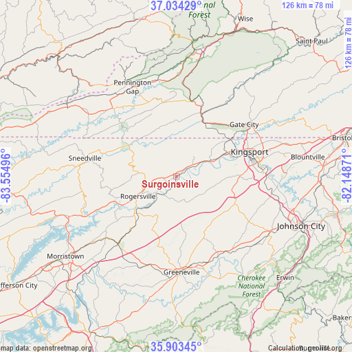
Surgoinsville GPS coordinates[2]
36° 28' 15.348" North, 82° 51' 6.588" West
| Map corner | latitude | longitude |
|---|---|---|
| Upper-left | 37.03429°, | -83.55496° |
| Center: | 36.47093°, | -82.85183° |
| Lower-right: | 35.90345°, | -82.14871° |
| Map W x H: | 125.7×125.7 km | = 78.1×78.1mi |
| max Lat: | 71.29058° ⇑68.1% North |
| Surgoinsville: | 36.47093° |
| min Lat: | ⇓31.9% South 19.06759° |
| min Long | Surgoinsville | max Long |
| -171.73463° | -82.85183° | -66.98998° |
| W 62.4%⇐ | ⇒37.6% E |
Elevation
Elevation of Surgoinsville is 347 m = 1138 ft, and this is 52.2 m = 171 ft above average elevation for this country.
| Max E: |
3189 m = 10463 ft | 20.7% |
| Surgoinsville | 347 m 1138 ft | |
| Avg. | 294.8 m = 967 ft | |
Min E: |
-60 m = -197 ft | 79.3% |
See also: United States elevation on elevation.city.
Geographical zone
Surgoinsville is located in North temperate zone (between Tropic of Cancer and the Arctic Circle). Distance of this Northern Tropic circle is 1449.3 km =900.6 mi to South.| Distance of | km | miles | from Surgoinsville |
|---|---|---|---|
| North Pole | 5951.9 | 3698.3 | to North |
| Arctic Circle | 3346 | 2079.1 | to North |
| Tropic Cancer | 1449.3 | 900.6 | to South |
| Equator | 4055.2 | 2519.8 | to South |


Nearby cities:
15 places around Surgoinsville: (largest is in red/bold)
• Bulls Gap
31.7 km =19.7 mi,  221°
221°
• Church Hill
13.6 km =8.5 mi,  65°
65°
• Colonial Heights
31.2 km =19.4 mi,  87°
87°
• Fall Branch
21.2 km =13.2 mi,  106°
106°
• Gate City
30.5 km =19 mi,  52°
52°
• Gray
34 km =21.1 mi,  99°
99°
• Greeneville
34.3 km =21.3 mi,  176°
176°
• Jonesville
33.5 km =20.8 mi,  316°
316°
• Kingsport
27.3 km =17 mi, 71°
• Mosheim
32.7 km =20.3 mi,  196°
196°
• Mount Carmel
19 km =11.8 mi,  64°
64°
• Rogersville
15.5 km =9.6 mi,  242°
242°
• Sneedville
33.3 km =20.7 mi,  281°
281°
• Tusculum
33.9 km =21.1 mi,  165°
165°
• Weber City
30.9 km =19.2 mi, 56°
Sources, notices
• [Note1] Compared only with cities in United States existing in our database
• [Src1] Map data: © OpenStreetMap contributors (CC-BY-SA)
• [Src2] Other city data from geonames.org with taken over terms of usage.
• [Src3] Geographical zone / Annual Mean Temperature by Robert A. Rohde @ Wikipedia
