Wartburg geodata
Wartburg (Tennessee) is a seat of a second-order administrative division; located in United States in America/New_York (GMT-4) time zone. With population of 904 people, there are 16951 cities with bigger population in this country. Compared to other cities in United States, 69.9% of cities are located further ↑North; 57% of cities are located further ←West and 84.9% of cities have lower elevation than Wartburg. Note1


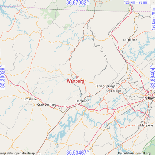
Wartburg GPS coordinates[2]
36° 6' 17.28" North, 84° 35' 49.776" West
| Map corner | latitude | longitude |
|---|---|---|
| Upper-left | 36.67082°, | -85.30029° |
| Center: | 36.1048°, | -84.59716° |
| Lower-right: | 35.53467°, | -83.89404° |
| Map W x H: | 126.3×126.3 km | = 78.5×78.5mi |
| max Lat: | 71.29058° ⇑69.9% North |
| Wartburg: | 36.1048° |
| min Lat: | ⇓30.1% South 19.06759° |
| min Long | Wartburg | max Long |
| -171.73463° | -84.59716° | -66.98998° |
| W 57%⇐ | ⇒43% E |
Elevation
Elevation of Wartburg is 422 m = 1385 ft, and this is 127.2 m = 417 ft above average elevation for this country.
| Max E: |
3189 m = 10463 ft | 15.1% |
| Wartburg | 422 m 1385 ft | |
| Avg. | 294.8 m = 967 ft | |
Min E: |
-60 m = -197 ft | 84.9% |
See also: United States elevation on elevation.city.
Geographical zone
Wartburg is located in North temperate zone (between Tropic of Cancer and the Arctic Circle). Distance of this Northern Tropic circle is 1408.6 km =875.3 mi to South.| Distance of | km | miles | from Wartburg |
|---|---|---|---|
| North Pole | 5992.6 | 3723.6 | to North |
| Arctic Circle | 3386.7 | 2104.4 | to North |
| Tropic Cancer | 1408.6 | 875.3 | to South |
| Equator | 4014.5 | 2494.5 | to South |


Nearby cities:
15 places around Wartburg: (largest is in red/bold)
• Clarkrange
38.7 km =24 mi,  283°
283°
• Coalfield
18 km =11.2 mi,  118°
118°
• Crab Orchard
33.3 km =20.7 mi,  229°
229°
• Fairfield Glade
28.5 km =17.7 mi,  245°
245°
• Grimsley
39.2 km =24.4 mi,  297°
297°
• Harriman
19.4 km =12.1 mi,  168°
168°
• Helenwood
36.4 km =22.6 mi,  7°
7°
• Huntsville
35.2 km =21.9 mi,  15°
15°
• Kingston
26.1 km =16.2 mi,  162°
162°
• Midtown
25.2 km =15.7 mi, 173°
• Oak Ridge
31.3 km =19.4 mi,  109°
109°
• Oliver Springs
23.7 km =14.7 mi, 106°
• Petros
13.9 km =8.6 mi,  94°
94°
• Rockwood
27.7 km =17.2 mi,  196°
196°
• Sunbright
16.7 km =10.4 mi,  337°
337°
Sources, notices
• [Note1] Compared only with cities in United States existing in our database
• [Src1] Map data: © OpenStreetMap contributors (CC-BY-SA)
• [Src2] Other city data from geonames.org with taken over terms of usage.
• [Src3] Geographical zone / Annual Mean Temperature by Robert A. Rohde @ Wikipedia
