Helenwood geodata
Helenwood (Tennessee) is a populated place; located in United States in America/New_York (GMT-4) time zone. With population of 865 people, there are 17241 cities with bigger population in this country. Compared to other cities in United States, 68.3% of cities are located further ↑North; 57.3% of cities are located further ←West and 85% of cities have lower elevation than Helenwood. Note1


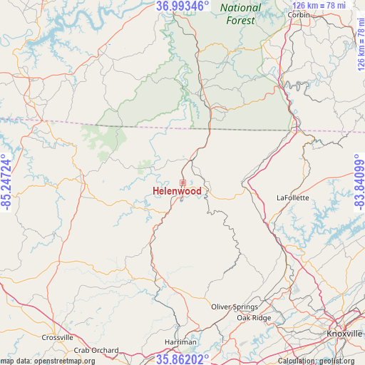
Helenwood GPS coordinates[2]
36° 25' 47.28" North, 84° 32' 38.796" West
| Map corner | latitude | longitude |
|---|---|---|
| Upper-left | 36.99346°, | -85.24724° |
| Center: | 36.4298°, | -84.54411° |
| Lower-right: | 35.86202°, | -83.84099° |
| Map W x H: | 125.8×125.8 km | = 78.2×78.2mi |
| max Lat: | 71.29058° ⇑68.3% North |
| Helenwood: | 36.4298° |
| min Lat: | ⇓31.7% South 19.06759° |
| min Long | Helenwood | max Long |
| -171.73463° | -84.54411° | -66.98998° |
| W 57.3%⇐ | ⇒42.7% E |
Elevation
Elevation of Helenwood is 424 m = 1391 ft, and this is 129.2 m = 424 ft above average elevation for this country.
| Max E: |
3189 m = 10463 ft | 15% |
| Helenwood | 424 m 1391 ft | |
| Avg. | 294.8 m = 967 ft | |
Min E: |
-60 m = -197 ft | 85% |
See also: United States elevation on elevation.city.
Geographical zone
Helenwood is located in North temperate zone (between Tropic of Cancer and the Arctic Circle). Distance of this Northern Tropic circle is 1444.7 km =897.7 mi to South.| Distance of | km | miles | from Helenwood |
|---|---|---|---|
| North Pole | 5956.4 | 3701.1 | to North |
| Arctic Circle | 3350.6 | 2082 | to North |
| Tropic Cancer | 1444.7 | 897.7 | to South |
| Equator | 4050.6 | 2516.9 | to South |


Nearby cities:
15 places around Helenwood: (largest is in red/bold)
• Allardt
30.9 km =19.2 mi,  259°
259°
• Caryville
32.2 km =20 mi,  116°
116°
• Hunter
36.9 km =22.9 mi,  101°
101°
• Huntsville
5.3 km =3.3 mi,  114°
114°
• Jacksboro
34.1 km =21.2 mi, 108°
• Jamestown
34.7 km =21.6 mi,  269°
269°
• LaFollette
38.3 km =23.8 mi, 97°
• Oneida
8.1 km =5 mi,  20°
20°
• Petros
38.2 km =23.7 mi,  166°
166°
• Pine Knot
26.3 km =16.3 mi, 20°
• Stearns
30.5 km =19 mi,  11°
11°
• Sunbright
23.6 km =14.7 mi,  208°
208°
• Wartburg
36.4 km =22.6 mi,  187°
187°
• Whitley City
33.3 km =20.7 mi, 11°
• Winfield
16.3 km =10.1 mi,  30°
30°
Sources, notices
• [Note1] Compared only with cities in United States existing in our database
• [Src1] Map data: © OpenStreetMap contributors (CC-BY-SA)
• [Src2] Other city data from geonames.org with taken over terms of usage.
• [Src3] Geographical zone / Annual Mean Temperature by Robert A. Rohde @ Wikipedia
