Annetta South geodata
Annetta South (Texas) is a populated place; located in United States in America/Chicago (GMT-5) time zone. With population of 558 people, there are 20177 cities with bigger population in this country. Compared to other cities in United States, 86.5% of cities are located further ↑North; 77.6% of cities are located further →East and 72.6% of cities have lower elevation than Annetta South. Note1


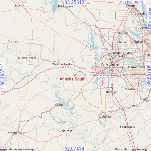
Annetta South GPS coordinates[2]
32° 40' 5.484" North, 97° 39' 38.088" West
| Map corner | latitude | longitude |
|---|---|---|
| Upper-left | 33.25812°, | -98.36371° |
| Center: | 32.66819°, | -97.66058° |
| Lower-right: | 32.07434°, | -96.95746° |
| Map W x H: | 131.6×131.6 km | = 81.8×81.8mi |
| max Lat: | 71.29058° ⇑86.5% North |
| Annetta South: | 32.66819° |
| min Lat: | ⇓13.5% South 19.06759° |
| min Long | Annetta South | max Long |
| -171.73463° | -97.66058° | -66.98998° |
| W 22.4%⇐ | ⇒77.6% E |
Elevation
Elevation of Annetta South is 299 m = 981 ft, and this is 4.2 m = 14 ft above average elevation for this country.
| Max E: |
3189 m = 10463 ft | 27.4% |
| Annetta South | 299 m 981 ft | |
| Avg. | 294.8 m = 967 ft | |
Min E: |
-60 m = -197 ft | 72.6% |
See also: United States elevation on elevation.city.
Geographical zone
Annetta South is located in North temperate zone (between Tropic of Cancer and the Arctic Circle). Distance of this Northern Tropic circle is 1026.4 km =637.8 mi to South.| Distance of | km | miles | from Annetta South |
|---|---|---|---|
| North Pole | 6374.7 | 3961.1 | to North |
| Arctic Circle | 3768.8 | 2341.8 | to North |
| Tropic Cancer | 1026.4 | 637.8 | to South |
| Equator | 3632.4 | 2257.1 | to South |


Nearby cities:
15 places around Annetta South: (largest is in red/bold)
• Aledo
6.3 km =3.9 mi,  60°
60°
• Annetta
4.8 km =3 mi,  342°
342°
• Annetta North
5.9 km =3.7 mi,  345°
345°
• Benbrook
18.7 km =11.6 mi,  88°
88°
• Cresson
15.6 km =9.7 mi,  165°
165°
• Hudson Oaks
10.8 km =6.7 mi, 336°
• Lake Worth
25.2 km =15.7 mi,  52°
52°
• Lakeside
23.2 km =14.4 mi,  42°
42°
• Oak Trail Shores
25.7 km =16 mi,  219°
219°
• Weatherford
16.3 km =10.1 mi,  308°
308°
• Western Lake
15 km =9.3 mi,  250°
250°
• Westover Hills
24.6 km =15.3 mi,  69°
69°
• Westworth
25.4 km =15.8 mi, 67°
• White Settlement
21.5 km =13.4 mi, 61°
• Willow Park
10.5 km =6.5 mi,  5°
5°
Sources, notices
• [Note1] Compared only with cities in United States existing in our database
• [Src1] Map data: © OpenStreetMap contributors (CC-BY-SA)
• [Src2] Other city data from geonames.org with taken over terms of usage.
• [Src3] Geographical zone / Annual Mean Temperature by Robert A. Rohde @ Wikipedia
