Atascocita geodata
Atascocita (Texas) is a populated place; located in United States in America/Chicago (GMT-5) time zone. With population of 65,844 people, there are 649 cities with bigger population in this country. Compared to other cities in United States, 93.4% of cities are located further ↑North; 71.6% of cities are located further →East and 86.2% of cities have higher elevation than Atascocita. Note1


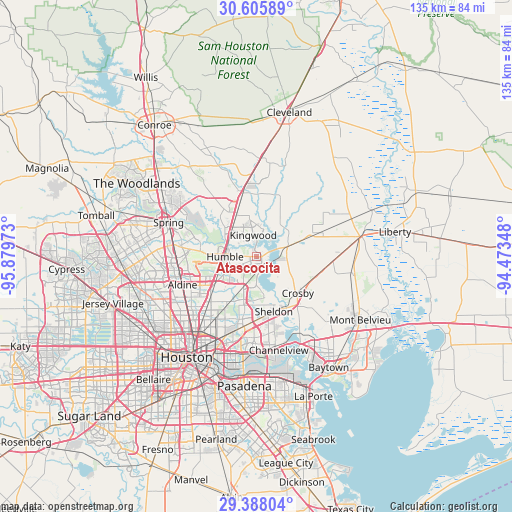
Atascocita GPS coordinates[2]
29° 59' 55.788" North, 95° 10' 35.76" West
| Map corner | latitude | longitude |
|---|---|---|
| Upper-left | 30.60589°, | -95.87973° |
| Center: | 29.99883°, | -95.1766° |
| Lower-right: | 29.38804°, | -94.47348° |
| Map W x H: | 135.4×135.4 km | = 84.1×84.1mi |
| max Lat: | 71.29058° ⇑93.4% North |
| Atascocita: | 29.99883° |
| min Lat: | ⇓6.6% South 19.06759° |
| min Long | Atascocita | max Long |
| -171.73463° | -95.1766° | -66.98998° |
| W 28.4%⇐ | ⇒71.6% E |
Elevation
Elevation of Atascocita is 25 m = 82 ft, and this is 269.8 m = 885 ft below average elevation for this country.
| Max E: |
3189 m = 10463 ft | 86.2% |
| Avg. | 294.8 m = 967 ft | |
| Atascocita | 25 m = 82 ft | |
Min E: |
-60 m = -197 ft | 13.8% |
See also: Atascocita elevation on elevation.city.
Geographical zone
Atascocita is located in North temperate zone (between Tropic of Cancer and the Arctic Circle). Distance of this Northern Tropic circle is 729.6 km =453.4 mi to South.| Distance of | km | miles | from Atascocita |
|---|---|---|---|
| North Pole | 6671.5 | 4145.5 | to North |
| Arctic Circle | 4065.6 | 2526.2 | to North |
| Tropic Cancer | 729.6 | 453.4 | to South |
| Equator | 3335.6 | 2072.6 | to South |


Nearby cities:
15 places around Atascocita: (largest is in red/bold)
• Aldine
21 km =13 mi,  249°
249°
• Barrett
17.2 km =10.7 mi,  140°
140°
• Channelview
25.5 km =15.8 mi,  166°
166°
• Cloverleaf
24.5 km =15.2 mi,  178°
178°
• Crosby
14.7 km =9.1 mi,  131°
131°
• Highlands
23.1 km =14.4 mi,  149°
149°
• Humble
8.2 km =5.1 mi,  270°
270°
• Kingwood Area
9 km =5.6 mi,  295°
295°
• Patton Village
21.6 km =13.4 mi,  1°
1°
• Plum Grove
25.3 km =15.7 mi,  18°
18°
• Porter Heights
22 km =13.7 mi,  320°
320°
• Roman Forest
20.1 km =12.5 mi, 3°
• Sheldon
15.3 km =9.5 mi,  162°
162°
• Spring
24.8 km =15.4 mi,  291°
291°
• Woodbranch
20.3 km =12.6 mi,  356°
356°
Sources, notices
• [Note1] Compared only with cities in United States existing in our database
• [Src1] Map data: © OpenStreetMap contributors (CC-BY-SA)
• [Src2] Other city data from geonames.org with taken over terms of usage.
• [Src3] Geographical zone / Annual Mean Temperature by Robert A. Rohde @ Wikipedia
