Channelview geodata
Channelview (Texas) is a populated place; located in United States in America/Chicago (GMT-5) time zone. With population of 38,289 people, there are 1264 cities with bigger population in this country. Compared to other cities in United States, 94% of cities are located further ↑North; 71.4% of cities are located further →East and 93% of cities have higher elevation than Channelview. Note1


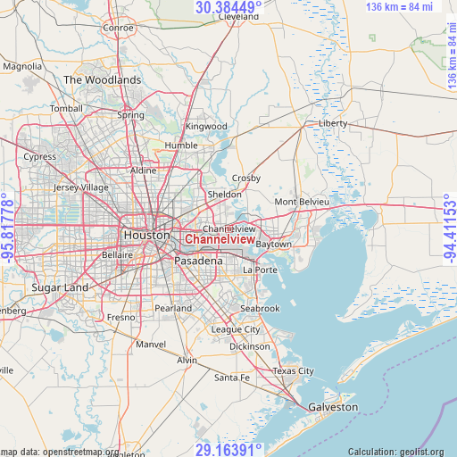
Channelview GPS coordinates[2]
29° 46' 33.816" North, 95° 6' 52.74" West
| Map corner | latitude | longitude |
|---|---|---|
| Upper-left | 30.38449°, | -95.81778° |
| Center: | 29.77606°, | -95.11465° |
| Lower-right: | 29.16391°, | -94.41153° |
| Map W x H: | 135.7×135.7 km | = 84.3×84.3mi |
| max Lat: | 71.29058° ⇑94% North |
| Channelview: | 29.77606° |
| min Lat: | ⇓6% South 19.06759° |
| min Long | Channelview | max Long |
| -171.73463° | -95.11465° | -66.98998° |
| W 28.6%⇐ | ⇒71.4% E |
Elevation
Elevation of Channelview is 11 m = 36 ft, and this is 283.8 m = 931 ft below average elevation for this country.
| Max E: |
3189 m = 10463 ft | 93% |
| Avg. | 294.8 m = 967 ft | |
| Channelview | 11 m = 36 ft | |
Min E: |
-60 m = -197 ft | 7% |
See also: United States elevation on elevation.city.
Geographical zone
Channelview is located in North temperate zone (between Tropic of Cancer and the Arctic Circle). Distance of this Northern Tropic circle is 704.9 km =438 mi to South.| Distance of | km | miles | from Channelview |
|---|---|---|---|
| North Pole | 6696.3 | 4160.9 | to North |
| Arctic Circle | 4090.4 | 2541.7 | to North |
| Tropic Cancer | 704.9 | 438 | to South |
| Equator | 3310.8 | 2057.2 | to South |


Nearby cities:
15 places around Channelview: (largest is in red/bold)
• Barrett
12.6 km =7.8 mi,  23°
23°
• Baytown
14 km =8.7 mi,  108°
108°
• Cloverleaf
5.5 km =3.4 mi,  272°
272°
• Crosby
15.9 km =9.9 mi, 18°
• Deer Park
7.9 km =4.9 mi,  186°
186°
• Galena Park
12.1 km =7.5 mi,  247°
247°
• Highlands
7.4 km =4.6 mi,  49°
49°
• Jacinto City
11.5 km =7.1 mi, 265°
• La Porte
15.3 km =9.5 mi,  143°
143°
• Mont Belvieu
23 km =14.3 mi,  69°
69°
• Pasadena
13.1 km =8.1 mi,  223°
223°
• Sheldon
10.3 km =6.4 mi,  352°
352°
• Shoreacres
20.1 km =12.5 mi,  149°
149°
• South Houston
17.2 km =10.7 mi, 222°
• Taylor Lake Village
23.2 km =14.4 mi,  164°
164°
Sources, notices
• [Note1] Compared only with cities in United States existing in our database
• [Src1] Map data: © OpenStreetMap contributors (CC-BY-SA)
• [Src2] Other city data from geonames.org with taken over terms of usage.
• [Src3] Geographical zone / Annual Mean Temperature by Robert A. Rohde @ Wikipedia
