Spring geodata
Spring (Texas) is a populated place; located in United States in America/Chicago (GMT-5) time zone. With population of 54,298 people, there are 856 cities with bigger population in this country. Compared to other cities in United States, 93.2% of cities are located further ↑North; 72.1% of cities are located further →East and 82.1% of cities have higher elevation than Spring. Note1


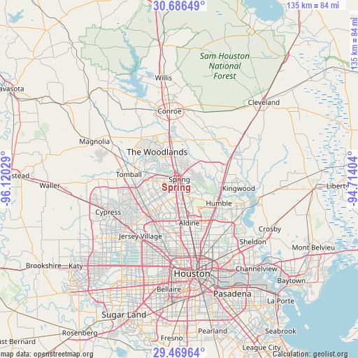
Spring GPS coordinates[2]
30° 4' 47.784" North, 95° 25' 1.776" West
| Map corner | latitude | longitude |
|---|---|---|
| Upper-left | 30.68649°, | -96.12029° |
| Center: | 30.07994°, | -95.41716° |
| Lower-right: | 29.46964°, | -94.71404° |
| Map W x H: | 135.3×135.3 km | = 84.1×84.1mi |
| max Lat: | 71.29058° ⇑93.2% North |
| Spring: | 30.07994° |
| min Lat: | ⇓6.8% South 19.06759° |
| min Long | Spring | max Long |
| -171.73463° | -95.41716° | -66.98998° |
| W 27.9%⇐ | ⇒72.1% E |
Elevation
Elevation of Spring is 38 m = 125 ft, and this is 256.8 m = 843 ft below average elevation for this country.
| Max E: |
3189 m = 10463 ft | 82.1% |
| Avg. | 294.8 m = 967 ft | |
| Spring | 38 m = 125 ft | |
Min E: |
-60 m = -197 ft | 17.9% |
See also: Spring elevation on elevation.city.
Geographical zone
Spring is located in North temperate zone (between Tropic of Cancer and the Arctic Circle). Distance of this Northern Tropic circle is 738.7 km =459 mi to South.| Distance of | km | miles | from Spring |
|---|---|---|---|
| North Pole | 6662.5 | 4139.9 | to North |
| Arctic Circle | 4056.6 | 2520.7 | to North |
| Tropic Cancer | 738.7 | 459 | to South |
| Equator | 3344.6 | 2078.2 | to South |


Nearby cities:
15 places around Spring: (largest is in red/bold)
• Aldine
16.8 km =10.4 mi,  167°
167°
• Atascocita
24.8 km =15.4 mi,  111°
111°
• Conroe
26.1 km =16.2 mi,  351°
351°
• Hudson
21.4 km =13.3 mi,  202°
202°
• Humble
17.4 km =10.8 mi,  121°
121°
• Jersey Village
25.6 km =15.9 mi,  213°
213°
• Kingwood Area
15.9 km =9.9 mi, 108°
• Oak Cliff Place
26.4 km =16.4 mi,  229°
229°
• Oak Ridge North
9.3 km =5.8 mi,  343°
343°
• Porter Heights
12.2 km =7.6 mi,  48°
48°
• Roman Forest
26.9 km =16.7 mi,  65°
65°
• Shenandoah
11.8 km =7.3 mi, 341°
• The Woodlands
11.1 km =6.9 mi,  321°
321°
• Tomball
19.2 km =11.9 mi,  275°
275°
• Woodbranch
24.7 km =15.3 mi,  62°
62°
Sources, notices
• [Note1] Compared only with cities in United States existing in our database
• [Src1] Map data: © OpenStreetMap contributors (CC-BY-SA)
• [Src2] Other city data from geonames.org with taken over terms of usage.
• [Src3] Geographical zone / Annual Mean Temperature by Robert A. Rohde @ Wikipedia
