Bayou Vista geodata
Bayou Vista (Texas) is a populated place; located in United States in America/Chicago (GMT-5) time zone. With population of 1,592 people, there are 13320 cities with bigger population in this country. Compared to other cities in United States, 94.9% of cities are located further ↑North; 70.9% of cities are located further →East and 98.8% of cities have higher elevation than Bayou Vista. Note1


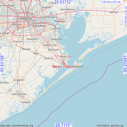
Bayou Vista GPS coordinates[2]
29° 19' 34.86" North, 94° 56' 18.708" West
| Map corner | latitude | longitude |
|---|---|---|
| Upper-left | 29.93752°, | -95.64166° |
| Center: | 29.32635°, | -94.93853° |
| Lower-right: | 28.7115°, | -94.23541° |
| Map W x H: | 136.3×136.3 km | = 84.7×84.7mi |
| max Lat: | 71.29058° ⇑94.9% North |
| Bayou Vista: | 29.32635° |
| min Lat: | ⇓5.1% South 19.06759° |
| min Long | Bayou Vista | max Long |
| -171.73463° | -94.93853° | -66.98998° |
| W 29.1%⇐ | ⇒70.9% E |
Elevation
Elevation of Bayou Vista is 4 m = 13 ft, and this is 290.8 m = 954 ft below average elevation for this country.
| Max E: |
3189 m = 10463 ft | 98.8% |
| Avg. | 294.8 m = 967 ft | |
| Bayou Vista | 4 m = 13 ft | |
Min E: |
-60 m = -197 ft | 1.2% |
See also: United States elevation on elevation.city.
Geographical zone
Bayou Vista is located in North temperate zone (between Tropic of Cancer and the Arctic Circle). Distance of this Northern Tropic circle is 654.9 km =406.9 mi to South.| Distance of | km | miles | from Bayou Vista |
|---|---|---|---|
| North Pole | 6746.3 | 4192 | to North |
| Arctic Circle | 4140.4 | 2572.7 | to North |
| Tropic Cancer | 654.9 | 406.9 | to South |
| Equator | 3260.8 | 2026.2 | to South |


Nearby cities:
15 places around Bayou Vista: (largest is in red/bold)
• Bacliff
20.7 km =12.9 mi,  345°
345°
• Clear Lake Shores
26.2 km =16.3 mi,  339°
339°
• Dickinson
18.5 km =11.5 mi,  323°
323°
• El Lago
28.3 km =17.6 mi, 338°
• Galveston
13.9 km =8.6 mi,  101°
101°
• Hitchcock
7.9 km =4.9 mi,  287°
287°
• Jamaica Beach
15.7 km =9.8 mi,  194°
194°
• Kemah
25.3 km =15.7 mi, 341°
• La Marque
5.7 km =3.5 mi,  325°
325°
• League City
25.2 km =15.7 mi, 323°
• San Leon
17.5 km =10.9 mi,  5°
5°
• Santa Fe
17.2 km =10.7 mi, 289°
• Seabrook
27.7 km =17.2 mi, 342°
• Texas City
7.3 km =4.5 mi,  28°
28°
• Tiki Island
3.9 km =2.4 mi,  147°
147°
Sources, notices
• [Note1] Compared only with cities in United States existing in our database
• [Src1] Map data: © OpenStreetMap contributors (CC-BY-SA)
• [Src2] Other city data from geonames.org with taken over terms of usage.
• [Src3] Geographical zone / Annual Mean Temperature by Robert A. Rohde @ Wikipedia
