Galveston geodata
Galveston (Texas) is a seat of a second-order administrative division; located in United States in America/Chicago (GMT-5) time zone. With population of 50,180 people, there are 946 cities with bigger population in this country. Compared to other cities in United States, 94.9% of cities are located further ↑North; 70.6% of cities are located further →East and 98.1% of cities have higher elevation than Galveston. Note1


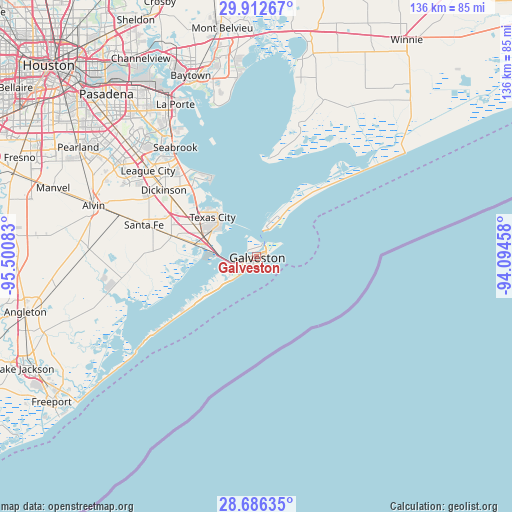
Galveston GPS coordinates[2]
29° 18' 4.86" North, 94° 47' 51.72" West
| Map corner | latitude | longitude |
|---|---|---|
| Upper-left | 29.91267°, | -95.50083° |
| Center: | 29.30135°, | -94.7977° |
| Lower-right: | 28.68635°, | -94.09458° |
| Map W x H: | 136.4×136.4 km | = 84.8×84.8mi |
| max Lat: | 71.29058° ⇑94.9% North |
| Galveston: | 29.30135° |
| min Lat: | ⇓5.1% South 19.06759° |
| min Long | Galveston | max Long |
| -171.73463° | -94.7977° | -66.98998° |
| W 29.4%⇐ | ⇒70.6% E |
Elevation
Elevation of Galveston is 5 m = 16 ft, and this is 289.8 m = 951 ft below average elevation for this country.
| Max E: |
3189 m = 10463 ft | 98.1% |
| Avg. | 294.8 m = 967 ft | |
| Galveston | 5 m = 16 ft | |
Min E: |
-60 m = -197 ft | 1.9% |
See also: Galveston elevation on elevation.city.
Geographical zone
Galveston is located in North temperate zone (between Tropic of Cancer and the Arctic Circle). Distance of this Northern Tropic circle is 652.1 km =405.2 mi to South.| Distance of | km | miles | from Galveston |
|---|---|---|---|
| North Pole | 6749.1 | 4193.7 | to North |
| Arctic Circle | 4143.2 | 2574.5 | to North |
| Tropic Cancer | 652.1 | 405.2 | to South |
| Equator | 3258 | 2024.4 | to South |


Nearby cities:
15 places around Galveston: (largest is in red/bold)
• Bacliff
29.6 km =18.4 mi,  320°
320°
• Bayou Vista
13.9 km =8.6 mi,  281°
281°
• Bolivar Peninsula
28.8 km =17.9 mi,  47°
47°
• Clear Lake Shores
35.6 km =22.1 mi, 320°
• Dickinson
30.3 km =18.8 mi,  305°
305°
• Hitchcock
21.8 km =13.5 mi, 283°
• Jamaica Beach
21.6 km =13.4 mi,  234°
234°
• Kemah
34.4 km =21.4 mi, 321°
• La Marque
18.4 km =11.4 mi,  293°
293°
• League City
36.8 km =22.9 mi, 308°
• San Leon
23.5 km =14.6 mi,  329°
329°
• Santa Fe
31.1 km =19.3 mi, 285°
• Seabrook
36.6 km =22.7 mi, 322°
• Texas City
13.7 km =8.5 mi, 312°
• Tiki Island
11.6 km =7.2 mi,  267°
267°
Sources, notices
• [Note1] Compared only with cities in United States existing in our database
• [Src1] Map data: © OpenStreetMap contributors (CC-BY-SA)
• [Src2] Other city data from geonames.org with taken over terms of usage.
• [Src3] Geographical zone / Annual Mean Temperature by Robert A. Rohde @ Wikipedia
