Scurry geodata
Scurry (Texas) is a populated place; located in United States in America/Chicago (GMT-5) time zone. With population of 736 people, there are 18345 cities with bigger population in this country. Compared to other cities in United States, 87.1% of cities are located further ↑North; 74.2% of cities are located further →East and 63.3% of cities have higher elevation than Scurry. Note1


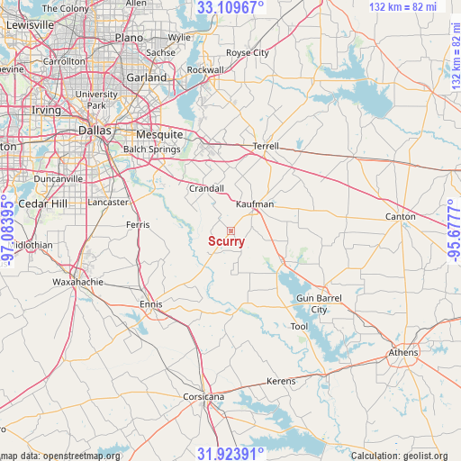
Scurry GPS coordinates[2]
32° 31' 7.5" North, 96° 22' 50.952" West
| Map corner | latitude | longitude |
|---|---|---|
| Upper-left | 33.10967°, | -97.08395° |
| Center: | 32.51875°, | -96.38082° |
| Lower-right: | 31.92391°, | -95.6777° |
| Map W x H: | 131.8×131.8 km | = 81.9×81.9mi |
| max Lat: | 71.29058° ⇑87.1% North |
| Scurry: | 32.51875° |
| min Lat: | ⇓12.9% South 19.06759° |
| min Long | Scurry | max Long |
| -171.73463° | -96.38082° | -66.98998° |
| W 25.8%⇐ | ⇒74.2% E |
Elevation
Elevation of Scurry is 137 m = 449 ft, and this is 157.8 m = 518 ft below average elevation for this country.
| Max E: |
3189 m = 10463 ft | 63.3% |
| Avg. | 294.8 m = 967 ft | |
| Scurry | 137 m = 449 ft | |
Min E: |
-60 m = -197 ft | 36.7% |
See also: United States elevation on elevation.city.
Geographical zone
Scurry is located in North temperate zone (between Tropic of Cancer and the Arctic Circle). Distance of this Northern Tropic circle is 1009.8 km =627.5 mi to South.| Distance of | km | miles | from Scurry |
|---|---|---|---|
| North Pole | 6391.3 | 3971.4 | to North |
| Arctic Circle | 3785.4 | 2352.1 | to North |
| Tropic Cancer | 1009.8 | 627.5 | to South |
| Equator | 3615.7 | 2246.7 | to South |


Nearby cities:
15 places around Scurry: (largest is in red/bold)
• Bristol
18.8 km =11.7 mi,  250°
250°
• Combine
14.3 km =8.9 mi,  302°
302°
• Crandall
14 km =8.7 mi,  329°
329°
• Ferris
26.7 km =16.6 mi,  273°
273°
• Forney
26.9 km =16.7 mi,  341°
341°
• Kaufman
10.3 km =6.4 mi,  40°
40°
• Kemp
16.5 km =10.3 mi,  120°
120°
• Oak Grove
6 km =3.7 mi,  72°
72°
• Oak Ridge
19 km =11.8 mi, 35°
• Palmer
28.6 km =17.8 mi, 250°
• Post Oak Bend City
14.1 km =8.8 mi,  26°
26°
• Seagoville
20 km =12.4 mi,  312°
312°
• Seven Points
27.1 km =16.8 mi,  144°
144°
• Talty
18.3 km =11.4 mi,  358°
358°
• Terrell
26.1 km =16.2 mi,  22°
22°
Sources, notices
• [Note1] Compared only with cities in United States existing in our database
• [Src1] Map data: © OpenStreetMap contributors (CC-BY-SA)
• [Src2] Other city data from geonames.org with taken over terms of usage.
• [Src3] Geographical zone / Annual Mean Temperature by Robert A. Rohde @ Wikipedia
