Brownwood geodata
Brownwood (Texas) is a seat of a second-order administrative division; located in United States in America/Chicago (GMT-5) time zone. With population of 19,031 people, there are 2647 cities with bigger population in this country. Compared to other cities in United States, 89.2% of cities are located further ↑North; 79.9% of cities are located further →East and 84.8% of cities have lower elevation than Brownwood. Note1


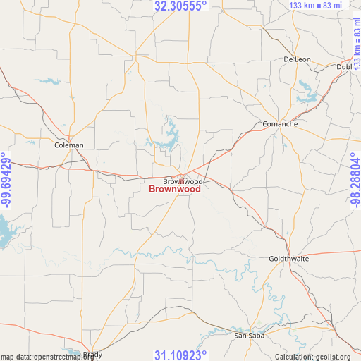
Brownwood GPS coordinates[2]
31° 42' 33.552" North, 98° 59' 28.176" West
| Map corner | latitude | longitude |
|---|---|---|
| Upper-left | 32.30555°, | -99.69429° |
| Center: | 31.70932°, | -98.99116° |
| Lower-right: | 31.10923°, | -98.28804° |
| Map W x H: | 133×133 km | = 82.6×82.6mi |
| max Lat: | 71.29058° ⇑89.2% North |
| Brownwood: | 31.70932° |
| min Lat: | ⇓10.8% South 19.06759° |
| min Long | Brownwood | max Long |
| -171.73463° | -98.99116° | -66.98998° |
| W 20.1%⇐ | ⇒79.9% E |
Elevation
Elevation of Brownwood is 420 m = 1378 ft, and this is 125.2 m = 411 ft above average elevation for this country.
| Max E: |
3189 m = 10463 ft | 15.2% |
| Brownwood | 420 m 1378 ft | |
| Avg. | 294.8 m = 967 ft | |
Min E: |
-60 m = -197 ft | 84.8% |
See also: United States elevation on elevation.city.
Geographical zone
Brownwood is located in North temperate zone (between Tropic of Cancer and the Arctic Circle). Distance of this Northern Tropic circle is 919.8 km =571.5 mi to South.| Distance of | km | miles | from Brownwood |
|---|---|---|---|
| North Pole | 6481.3 | 4027.3 | to North |
| Arctic Circle | 3875.4 | 2408.1 | to North |
| Tropic Cancer | 919.8 | 571.5 | to South |
| Equator | 3525.7 | 2190.8 | to South |


Nearby cities:
15 places around Brownwood: (largest is in red/bold)
• Bangs
13.4 km =8.3 mi,  273°
273°
• Brady
71.7 km =44.6 mi,  207°
207°
• Cisco
75.5 km =46.9 mi,  0°
0°
• Coleman
43.2 km =26.8 mi,  287°
287°
• Comanche
42.2 km =26.2 mi,  60°
60°
• Cross Plains
49.2 km =30.6 mi,  340°
340°
• De Leon
62 km =38.5 mi,  43°
43°
• Dublin
74.2 km =46.1 mi, 55°
• Early
5.6 km =3.5 mi,  49°
49°
• Goldthwaite
49.2 km =30.6 mi,  125°
125°
• Gorman
63.7 km =39.6 mi,  28°
28°
• Lake Brownwood
14.1 km =8.8 mi,  353°
353°
• Rising Star
43.1 km =26.8 mi, 3°
• San Saba
62.7 km =39 mi,  155°
155°
• Santa Anna
31.5 km =19.6 mi,  276°
276°
Sources, notices
• [Note1] Compared only with cities in United States existing in our database
• [Src1] Map data: © OpenStreetMap contributors (CC-BY-SA)
• [Src2] Other city data from geonames.org with taken over terms of usage.
• [Src3] Geographical zone / Annual Mean Temperature by Robert A. Rohde @ Wikipedia
