Cross Plains geodata
Cross Plains (Texas) is a populated place; located in United States in America/Chicago (GMT-5) time zone. With population of 970 people, there are 16492 cities with bigger population in this country. Compared to other cities in United States, 88.3% of cities are located further ↑North; 80.1% of cities are located further →East and 88.5% of cities have lower elevation than Cross Plains. Note1


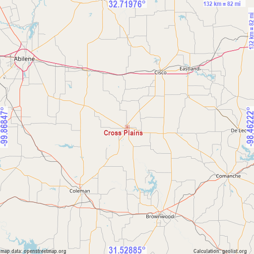
Cross Plains GPS coordinates[2]
32° 7' 34.5" North, 99° 9' 55.224" West
| Map corner | latitude | longitude |
|---|---|---|
| Upper-left | 32.71976°, | -99.86847° |
| Center: | 32.12625°, | -99.16534° |
| Lower-right: | 31.52885°, | -98.46222° |
| Map W x H: | 132.4×132.4 km | = 82.3×82.3mi |
| max Lat: | 71.29058° ⇑88.3% North |
| Cross Plains: | 32.12625° |
| min Lat: | ⇓11.7% South 19.06759° |
| min Long | Cross Plains | max Long |
| -171.73463° | -99.16534° | -66.98998° |
| W 19.9%⇐ | ⇒80.1% E |
Elevation
Elevation of Cross Plains is 533 m = 1749 ft, and this is 238.2 m = 781 ft above average elevation for this country.
| Max E: |
3189 m = 10463 ft | 11.5% |
| Cross Plains | 533 m 1749 ft | |
| Avg. | 294.8 m = 967 ft | |
Min E: |
-60 m = -197 ft | 88.5% |
See also: United States elevation on elevation.city.
Geographical zone
Cross Plains is located in North temperate zone (between Tropic of Cancer and the Arctic Circle). Distance of this Northern Tropic circle is 966.2 km =600.4 mi to South.| Distance of | km | miles | from Cross Plains |
|---|---|---|---|
| North Pole | 6435 | 3998.5 | to North |
| Arctic Circle | 3829.1 | 2379.3 | to North |
| Tropic Cancer | 966.2 | 600.4 | to South |
| Equator | 3572.1 | 2219.6 | to South |


Nearby cities:
15 places around Cross Plains: (largest is in red/bold)
• Baird
36.7 km =22.8 mi,  324°
324°
• Bangs
45.6 km =28.3 mi,  176°
176°
• Brownwood
49.2 km =30.6 mi,  160°
160°
• Cisco
34 km =21.1 mi,  30°
30°
• Clyde
43.8 km =27.2 mi, 315°
• Coleman
41.4 km =25.7 mi,  216°
216°
• Comanche
58.8 km =36.5 mi,  115°
115°
• De Leon
59.3 km =36.8 mi,  91°
91°
• Early
47.5 km =29.5 mi,  154°
154°
• Eastland
44.8 km =27.8 mi,  46°
46°
• Gorman
47.6 km =29.6 mi,  78°
78°
• Lake Brownwood
35.6 km =22.1 mi, 155°
• Potosi
51.4 km =31.9 mi,  296°
296°
• Rising Star
19.3 km =12 mi,  100°
100°
• Santa Anna
45.2 km =28.1 mi,  199°
199°
Sources, notices
• [Note1] Compared only with cities in United States existing in our database
• [Src1] Map data: © OpenStreetMap contributors (CC-BY-SA)
• [Src2] Other city data from geonames.org with taken over terms of usage.
• [Src3] Geographical zone / Annual Mean Temperature by Robert A. Rohde @ Wikipedia
