Brady geodata
Brady (Texas) is a seat of a second-order administrative division; located in United States in America/Chicago (GMT-5) time zone. With population of 5,549 people, there are 6722 cities with bigger population in this country. Compared to other cities in United States, 90.5% of cities are located further ↑North; 80.2% of cities are located further →East and 88.3% of cities have lower elevation than Brady. Note1


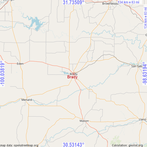
Brady GPS coordinates[2]
31° 8' 6.612" North, 99° 20' 6.216" West
| Map corner | latitude | longitude |
|---|---|---|
| Upper-left | 31.73509°, | -100.03819° |
| Center: | 31.13517°, | -99.33506° |
| Lower-right: | 30.53143°, | -98.63194° |
| Map W x H: | 133.8×133.8 km | = 83.1×83.1mi |
| max Lat: | 71.29058° ⇑90.5% North |
| Brady: | 31.13517° |
| min Lat: | ⇓9.5% South 19.06759° |
| min Long | Brady | max Long |
| -171.73463° | -99.33506° | -66.98998° |
| W 19.8%⇐ | ⇒80.2% E |
Elevation
Elevation of Brady is 519 m = 1703 ft, and this is 224.2 m = 736 ft above average elevation for this country.
| Max E: |
3189 m = 10463 ft | 11.7% |
| Brady | 519 m 1703 ft | |
| Avg. | 294.8 m = 967 ft | |
Min E: |
-60 m = -197 ft | 88.3% |
See also: United States elevation on elevation.city.
Geographical zone
Brady is located in North temperate zone (between Tropic of Cancer and the Arctic Circle). Distance of this Northern Tropic circle is 856 km =531.9 mi to South.| Distance of | km | miles | from Brady |
|---|---|---|---|
| North Pole | 6545.2 | 4067 | to North |
| Arctic Circle | 3939.3 | 2447.8 | to North |
| Tropic Cancer | 856 | 531.9 | to South |
| Equator | 3461.9 | 2151.1 | to South |


Nearby cities:
15 places around Brady: (largest is in red/bold)
• Ballinger
88.7 km =55.1 mi,  319°
319°
• Bangs
67.5 km =41.9 mi,  16°
16°
• Brownwood
71.7 km =44.6 mi,  27°
27°
• Coleman
77.5 km =48.2 mi,  353°
353°
• Early
76.9 km =47.8 mi, 28°
• Eden
49.4 km =30.7 mi,  280°
280°
• Goldthwaite
80.6 km =50.1 mi,  64°
64°
• Junction
83.1 km =51.6 mi,  210°
210°
• Lake Brownwood
83.8 km =52.1 mi, 21°
• Llano
75.5 km =46.9 mi,  123°
123°
• Mason
44.1 km =27.4 mi,  166°
166°
• Menard
49.3 km =30.6 mi,  240°
240°
• Paint Rock
69.4 km =43.1 mi,  306°
306°
• San Saba
59.1 km =36.7 mi,  83°
83°
• Santa Anna
67.5 km =41.9 mi,  1°
1°
Sources, notices
• [Note1] Compared only with cities in United States existing in our database
• [Src1] Map data: © OpenStreetMap contributors (CC-BY-SA)
• [Src2] Other city data from geonames.org with taken over terms of usage.
• [Src3] Geographical zone / Annual Mean Temperature by Robert A. Rohde @ Wikipedia
