Baytown geodata
Baytown (Texas) is a populated place; located in United States in America/Chicago (GMT-5) time zone. With population of 76,335 people, there are 526 cities with bigger population in this country. Compared to other cities in United States, 94% of cities are located further ↑North; 71.1% of cities are located further →East and 94.8% of cities have higher elevation than Baytown. Note1


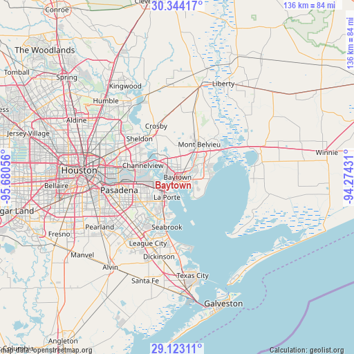
Baytown GPS coordinates[2]
29° 44' 7.8" North, 94° 58' 38.748" West
| Map corner | latitude | longitude |
|---|---|---|
| Upper-left | 30.34417°, | -95.68056° |
| Center: | 29.7355°, | -94.97743° |
| Lower-right: | 29.12311°, | -94.27431° |
| Map W x H: | 135.8×135.8 km | = 84.4×84.4mi |
| max Lat: | 71.29058° ⇑94% North |
| Baytown: | 29.7355° |
| min Lat: | ⇓6% South 19.06759° |
| min Long | Baytown | max Long |
| -171.73463° | -94.97743° | -66.98998° |
| W 28.9%⇐ | ⇒71.1% E |
Elevation
Elevation of Baytown is 9 m = 30 ft, and this is 285.8 m = 938 ft below average elevation for this country.
| Max E: |
3189 m = 10463 ft | 94.8% |
| Avg. | 294.8 m = 967 ft | |
| Baytown | 9 m = 30 ft | |
Min E: |
-60 m = -197 ft | 5.2% |
See also: Baytown elevation on elevation.city.
Geographical zone
Baytown is located in North temperate zone (between Tropic of Cancer and the Arctic Circle). Distance of this Northern Tropic circle is 700.4 km =435.2 mi to South.| Distance of | km | miles | from Baytown |
|---|---|---|---|
| North Pole | 6700.8 | 4163.7 | to North |
| Arctic Circle | 4094.9 | 2544.5 | to North |
| Tropic Cancer | 700.4 | 435.2 | to South |
| Equator | 3306.3 | 2054.4 | to South |


Nearby cities:
15 places around Baytown: (largest is in red/bold)
• Barrett
18.1 km =11.2 mi,  332°
332°
• Beach City
11.7 km =7.3 mi,  133°
133°
• Channelview
14 km =8.7 mi,  288°
288°
• Cloverleaf
19.4 km =12.1 mi,  284°
284°
• Cove
19.7 km =12.2 mi,  58°
58°
• Deer Park
14.5 km =9 mi,  256°
256°
• El Lago
20.2 km =12.6 mi,  198°
198°
• Highlands
12 km =7.5 mi,  320°
320°
• La Porte
8.7 km =5.4 mi,  207°
207°
• Mont Belvieu
15 km =9.3 mi,  33°
33°
• Old River-Winfree
20.3 km =12.6 mi,  43°
43°
• Seabrook
19.6 km =12.2 mi,  193°
193°
• Sheldon
20.7 km =12.9 mi, 315°
• Shoreacres
13.2 km =8.2 mi, 193°
• Taylor Lake Village
19.2 km =11.9 mi, 201°
Sources, notices
• [Note1] Compared only with cities in United States existing in our database
• [Src1] Map data: © OpenStreetMap contributors (CC-BY-SA)
• [Src2] Other city data from geonames.org with taken over terms of usage.
• [Src3] Geographical zone / Annual Mean Temperature by Robert A. Rohde @ Wikipedia
