Cinco Ranch geodata
Cinco Ranch (Texas) is a populated place; located in United States in America/Chicago (GMT-5) time zone. With population of 18,274 people, there are 2744 cities with bigger population in this country. Compared to other cities in United States, 94% of cities are located further ↑North; 73% of cities are located further →East and 82.9% of cities have higher elevation than Cinco Ranch. Note1


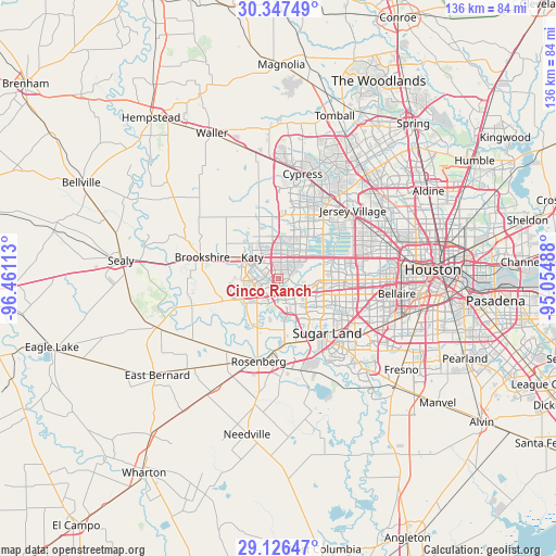
Cinco Ranch GPS coordinates[2]
29° 44' 19.824" North, 95° 45' 28.8" West
| Map corner | latitude | longitude |
|---|---|---|
| Upper-left | 30.34749°, | -96.46113° |
| Center: | 29.73884°, | -95.758° |
| Lower-right: | 29.12647°, | -95.05488° |
| Map W x H: | 135.8×135.8 km | = 84.4×84.4mi |
| max Lat: | 71.29058° ⇑94% North |
| Cinco Ranch: | 29.73884° |
| min Lat: | ⇓6% South 19.06759° |
| min Long | Cinco Ranch | max Long |
| -171.73463° | -95.758° | -66.98998° |
| W 27%⇐ | ⇒73% E |
Elevation
Elevation of Cinco Ranch is 35 m = 115 ft, and this is 259.8 m = 852 ft below average elevation for this country.
| Max E: |
3189 m = 10463 ft | 82.9% |
| Avg. | 294.8 m = 967 ft | |
| Cinco Ranch | 35 m = 115 ft | |
Min E: |
-60 m = -197 ft | 17.1% |
See also: United States elevation on elevation.city.
Geographical zone
Cinco Ranch is located in North temperate zone (between Tropic of Cancer and the Arctic Circle). Distance of this Northern Tropic circle is 700.7 km =435.4 mi to South.| Distance of | km | miles | from Cinco Ranch |
|---|---|---|---|
| North Pole | 6700.4 | 4163.4 | to North |
| Arctic Circle | 4094.5 | 2544.2 | to North |
| Tropic Cancer | 700.7 | 435.4 | to South |
| Equator | 3306.6 | 2054.6 | to South |


Nearby cities:
15 places around Cinco Ranch: (largest is in red/bold)
• Alief
15.9 km =9.9 mi,  101°
101°
• Brookshire
19.4 km =12.1 mi,  285°
285°
• Cumings
18.3 km =11.4 mi,  192°
192°
• Four Corners
12.4 km =7.7 mi,  128°
128°
• Fulshear
14.7 km =9.1 mi,  248°
248°
• Greatwood
22 km =13.7 mi,  158°
158°
• Katy
8.3 km =5.2 mi,  309°
309°
• Meadows Place
19.1 km =11.9 mi,  120°
120°
• Mission Bend
10.3 km =6.4 mi, 119°
• New Territory
17.7 km =11 mi, 155°
• Pecan Grove
12.8 km =8 mi,  168°
168°
• Richmond
17.4 km =10.8 mi,  180°
180°
• Rosenberg
20.8 km =12.9 mi, 193°
• Sugar Land
17.8 km =11.1 mi,  138°
138°
• Weston Lakes
18.2 km =11.3 mi, 250°
Sources, notices
• [Note1] Compared only with cities in United States existing in our database
• [Src1] Map data: © OpenStreetMap contributors (CC-BY-SA)
• [Src2] Other city data from geonames.org with taken over terms of usage.
• [Src3] Geographical zone / Annual Mean Temperature by Robert A. Rohde @ Wikipedia
