Weston Lakes geodata
Weston Lakes (Texas) is a populated place; located in United States in America/Chicago (GMT-5) time zone. With population of 2,589 people, there are 10421 cities with bigger population in this country. Compared to other cities in United States, 94.2% of cities are located further ↑North; 73.3% of cities are located further →East and 82.9% of cities have higher elevation than Weston Lakes. Note1


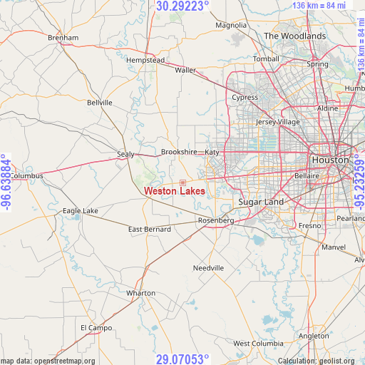
Weston Lakes GPS coordinates[2]
29° 40' 59.664" North, 95° 56' 8.556" West
| Map corner | latitude | longitude |
|---|---|---|
| Upper-left | 30.29223°, | -96.63884° |
| Center: | 29.68324°, | -95.93571° |
| Lower-right: | 29.07053°, | -95.23259° |
| Map W x H: | 135.8×135.8 km | = 84.4×84.4mi |
| max Lat: | 71.29058° ⇑94.2% North |
| Weston Lakes: | 29.68324° |
| min Lat: | ⇓5.8% South 19.06759° |
| min Long | Weston Lakes | max Long |
| -171.73463° | -95.93571° | -66.98998° |
| W 26.7%⇐ | ⇒73.3% E |
Elevation
Elevation of Weston Lakes is 35 m = 115 ft, and this is 259.8 m = 852 ft below average elevation for this country.
| Max E: |
3189 m = 10463 ft | 82.9% |
| Avg. | 294.8 m = 967 ft | |
| Weston Lakes | 35 m = 115 ft | |
Min E: |
-60 m = -197 ft | 17.1% |
See also: United States elevation on elevation.city.
Geographical zone
Weston Lakes is located in North temperate zone (between Tropic of Cancer and the Arctic Circle). Distance of this Northern Tropic circle is 694.5 km =431.5 mi to South.| Distance of | km | miles | from Weston Lakes |
|---|---|---|---|
| North Pole | 6706.6 | 4167.3 | to North |
| Arctic Circle | 4100.7 | 2548.1 | to North |
| Tropic Cancer | 694.5 | 431.5 | to South |
| Equator | 3300.5 | 2050.8 | to South |


Nearby cities:
15 places around Weston Lakes: (largest is in red/bold)
• Beasley
20.7 km =12.9 mi,  175°
175°
• Brookshire
11.5 km =7.1 mi,  352°
352°
• Cinco Ranch
18.2 km =11.3 mi,  70°
70°
• Cumings
17.6 km =10.9 mi,  131°
131°
• East Bernard
21.4 km =13.3 mi,  217°
217°
• Fulshear
3.6 km =2.2 mi,  77°
77°
• Katy
15.7 km =9.8 mi,  43°
43°
• Pattison
16.8 km =10.4 mi,  340°
340°
• Pecan Grove
20.7 km =12.9 mi,  107°
107°
• Richmond
20.3 km =12.6 mi,  123°
123°
• Rosenberg
18.6 km =11.6 mi,  138°
138°
• San Felipe
20.1 km =12.5 mi,  307°
307°
• Sealy
24 km =14.9 mi,  296°
296°
• Simonton
4 km =2.5 mi,  263°
263°
• Wallis
13.8 km =8.6 mi,  245°
245°
Sources, notices
• [Note1] Compared only with cities in United States existing in our database
• [Src1] Map data: © OpenStreetMap contributors (CC-BY-SA)
• [Src2] Other city data from geonames.org with taken over terms of usage.
• [Src3] Geographical zone / Annual Mean Temperature by Robert A. Rohde @ Wikipedia
