DeSoto geodata
DeSoto (Texas) is a populated place; located in United States in America/Chicago (GMT-5) time zone. With population of 52,486 people, there are 894 cities with bigger population in this country. Compared to other cities in United States, 86.8% of cities are located further ↑North; 75.3% of cities are located further →East and 51.7% of cities have lower elevation than DeSoto. Note1


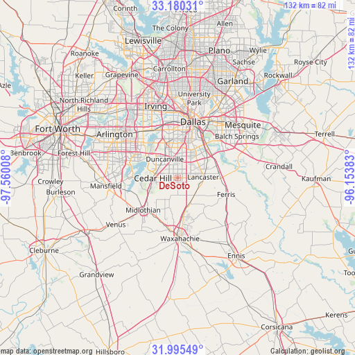
DeSoto GPS coordinates[2]
32° 35' 23.496" North, 96° 51' 25.02" West
| Map corner | latitude | longitude |
|---|---|---|
| Upper-left | 33.18031°, | -97.56008° |
| Center: | 32.58986°, | -96.85695° |
| Lower-right: | 31.99549°, | -96.15383° |
| Map W x H: | 131.7×131.7 km | = 81.8×81.8mi |
| max Lat: | 71.29058° ⇑86.8% North |
| DeSoto: | 32.58986° |
| min Lat: | ⇓13.2% South 19.06759° |
| min Long | DeSoto | max Long |
| -171.73463° | -96.85695° | -66.98998° |
| W 24.7%⇐ | ⇒75.3% E |
Elevation
Elevation of DeSoto is 205 m = 673 ft, and this is 89.8 m = 295 ft below average elevation for this country.
| Max E: |
3189 m = 10463 ft | 48.3% |
| Avg. | 294.8 m = 967 ft | |
| DeSoto | 205 m = 673 ft | |
Min E: |
-60 m = -197 ft | 51.7% |
See also: DeSoto elevation on elevation.city.
Geographical zone
DeSoto is located in North temperate zone (between Tropic of Cancer and the Arctic Circle). Distance of this Northern Tropic circle is 1017.7 km =632.4 mi to South.| Distance of | km | miles | from DeSoto |
|---|---|---|---|
| North Pole | 6383.4 | 3966.5 | to North |
| Arctic Circle | 3777.5 | 2347.2 | to North |
| Tropic Cancer | 1017.7 | 632.4 | to South |
| Equator | 3623.7 | 2251.7 | to South |


Nearby cities:
15 places around DeSoto: (largest is in red/bold)
• Cedar Hill
9.3 km =5.8 mi,  269°
269°
• Cockrell Hill
16.5 km =10.3 mi,  350°
350°
• Duncanville
8.4 km =5.2 mi,  325°
325°
• Ferris
19 km =11.8 mi,  109°
109°
• Glenn Heights
4.6 km =2.9 mi,  179°
179°
• Grand Prairie
21.8 km =13.5 mi,  322°
322°
• Hutchins
15 km =9.3 mi,  63°
63°
• Lancaster
9.5 km =5.9 mi,  88°
88°
• Midlothian
17.6 km =10.9 mi,  227°
227°
• Oak Leaf
7.7 km =4.8 mi, 178°
• Ovilla
7.6 km =4.7 mi,  201°
201°
• Pecan Hill
13.3 km =8.3 mi,  149°
149°
• Red Oak
9.4 km =5.8 mi, 148°
• Shamrock
3 km =1.9 mi,  290°
290°
• Wilmer
16.1 km =10 mi, 90°
Sources, notices
• [Note1] Compared only with cities in United States existing in our database
• [Src1] Map data: © OpenStreetMap contributors (CC-BY-SA)
• [Src2] Other city data from geonames.org with taken over terms of usage.
• [Src3] Geographical zone / Annual Mean Temperature by Robert A. Rohde @ Wikipedia
