Duncanville geodata
Duncanville (Texas) is a populated place; located in United States in America/Chicago (GMT-5) time zone. With population of 39,826 people, there are 1214 cities with bigger population in this country. Compared to other cities in United States, 86.6% of cities are located further ↑North; 75.5% of cities are located further →East and 56.4% of cities have lower elevation than Duncanville. Note1


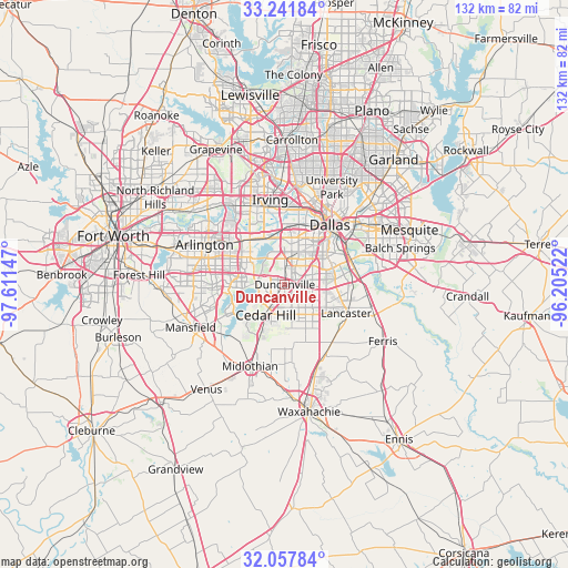
Duncanville GPS coordinates[2]
32° 39' 6.48" North, 96° 54' 30.024" West
| Map corner | latitude | longitude |
|---|---|---|
| Upper-left | 33.24184°, | -97.61147° |
| Center: | 32.6518°, | -96.90834° |
| Lower-right: | 32.05784°, | -96.20522° |
| Map W x H: | 131.6×131.6 km | = 81.8×81.8mi |
| max Lat: | 71.29058° ⇑86.6% North |
| Duncanville: | 32.6518° |
| min Lat: | ⇓13.4% South 19.06759° |
| min Long | Duncanville | max Long |
| -171.73463° | -96.90834° | -66.98998° |
| W 24.5%⇐ | ⇒75.5% E |
Elevation
Elevation of Duncanville is 224 m = 735 ft, and this is 70.8 m = 232 ft below average elevation for this country.
| Max E: |
3189 m = 10463 ft | 43.6% |
| Avg. | 294.8 m = 967 ft | |
| Duncanville | 224 m = 735 ft | |
Min E: |
-60 m = -197 ft | 56.4% |
See also: United States elevation on elevation.city.
Geographical zone
Duncanville is located in North temperate zone (between Tropic of Cancer and the Arctic Circle). Distance of this Northern Tropic circle is 1024.6 km =636.7 mi to South.| Distance of | km | miles | from Duncanville |
|---|---|---|---|
| North Pole | 6376.5 | 3962.2 | to North |
| Arctic Circle | 3770.6 | 2342.9 | to North |
| Tropic Cancer | 1024.6 | 636.7 | to South |
| Equator | 3630.5 | 2255.9 | to South |


Nearby cities:
15 places around Duncanville: (largest is in red/bold)
• Arlington
20.9 km =13 mi,  296°
296°
• Cedar Hill
8.3 km =5.2 mi,  212°
212°
• Cockrell Hill
9.6 km =6 mi,  12°
12°
• Dallas
17.4 km =10.8 mi,  33°
33°
• DeSoto
8.4 km =5.2 mi,  145°
145°
• Glenn Heights
12.4 km =7.7 mi,  157°
157°
• Grand Prairie
13.4 km =8.3 mi,  321°
321°
• Hutchins
18.3 km =11.4 mi,  90°
90°
• Irving
18.4 km =11.4 mi,  348°
348°
• Lancaster
15.7 km =9.8 mi,  114°
114°
• Midlothian
20.5 km =12.7 mi,  203°
203°
• Oak Leaf
15.4 km =9.6 mi, 161°
• Ovilla
14.1 km =8.8 mi,  171°
171°
• Red Oak
17.8 km =11.1 mi, 146°
• Shamrock
6.2 km =3.9 mi, 161°
Sources, notices
• [Note1] Compared only with cities in United States existing in our database
• [Src1] Map data: © OpenStreetMap contributors (CC-BY-SA)
• [Src2] Other city data from geonames.org with taken over terms of usage.
• [Src3] Geographical zone / Annual Mean Temperature by Robert A. Rohde @ Wikipedia
