Grand Prairie geodata
Grand Prairie (Texas) is a populated place; located in United States in America/Chicago (GMT-5) time zone. With population of 187,809 people, there are 140 cities with bigger population in this country. Compared to other cities in United States, 86.2% of cities are located further ↑North; 75.7% of cities are located further →East and 58.6% of cities have higher elevation than Grand Prairie. Note1


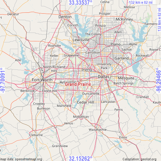
Grand Prairie GPS coordinates[2]
32° 44' 45.456" North, 96° 59' 52.008" West
| Map corner | latitude | longitude |
|---|---|---|
| Upper-left | 33.33537°, | -97.70091° |
| Center: | 32.74596°, | -96.99778° |
| Lower-right: | 32.15262°, | -96.29466° |
| Map W x H: | 131.5×131.5 km | = 81.7×81.7mi |
| max Lat: | 71.29058° ⇑86.2% North |
| Grand Prairie: | 32.74596° |
| min Lat: | ⇓13.8% South 19.06759° |
| min Long | Grand Prairie | max Long |
| -171.73463° | -96.99778° | -66.98998° |
| W 24.3%⇐ | ⇒75.7% E |
Elevation
Elevation of Grand Prairie is 162 m = 531 ft, and this is 132.8 m = 436 ft below average elevation for this country.
| Max E: |
3189 m = 10463 ft | 58.6% |
| Avg. | 294.8 m = 967 ft | |
| Grand Prairie | 162 m = 531 ft | |
Min E: |
-60 m = -197 ft | 41.4% |
See also: Grand Prairie elevation on elevation.city.
Geographical zone
Grand Prairie is located in North temperate zone (between Tropic of Cancer and the Arctic Circle). Distance of this Northern Tropic circle is 1035.1 km =643.2 mi to South.| Distance of | km | miles | from Grand Prairie |
|---|---|---|---|
| North Pole | 6366.1 | 3955.7 | to North |
| Arctic Circle | 3760.2 | 2336.5 | to North |
| Tropic Cancer | 1035.1 | 643.2 | to South |
| Equator | 3641 | 2262.4 | to South |


Nearby cities:
15 places around Grand Prairie: (largest is in red/bold)
• Arlington
10.4 km =6.5 mi,  263°
263°
• Bedford
17.4 km =10.8 mi,  308°
308°
• Cedar Hill
17.9 km =11.1 mi,  167°
167°
• Cockrell Hill
10.4 km =6.5 mi,  95°
95°
• Colleyville
21 km =13 mi,  315°
315°
• Dallas
18.3 km =11.4 mi,  77°
77°
• Dalworthington Gardens
15.5 km =9.6 mi,  252°
252°
• Duncanville
13.4 km =8.3 mi,  141°
141°
• Euless
12.8 km =8 mi, 322°
• Highland Park
21.6 km =13.4 mi,  63°
63°
• Hurst
18.3 km =11.4 mi,  298°
298°
• Irving
8.8 km =5.5 mi,  31°
31°
• Pantego
15.2 km =9.4 mi, 256°
• Shamrock
19.3 km =12 mi,  147°
147°
• University Park
21.8 km =13.5 mi, 57°
Sources, notices
• [Note1] Compared only with cities in United States existing in our database
• [Src1] Map data: © OpenStreetMap contributors (CC-BY-SA)
• [Src2] Other city data from geonames.org with taken over terms of usage.
• [Src3] Geographical zone / Annual Mean Temperature by Robert A. Rohde @ Wikipedia
