Denton geodata
Denton (Texas) is a seat of a second-order administrative division; located in United States in America/Chicago (GMT-5) time zone. With population of 131,044 people, there are 231 cities with bigger population in this country. Compared to other cities in United States, 84.3% of cities are located further ↑North; 76.1% of cities are located further →East and 51.9% of cities have lower elevation than Denton. Note1


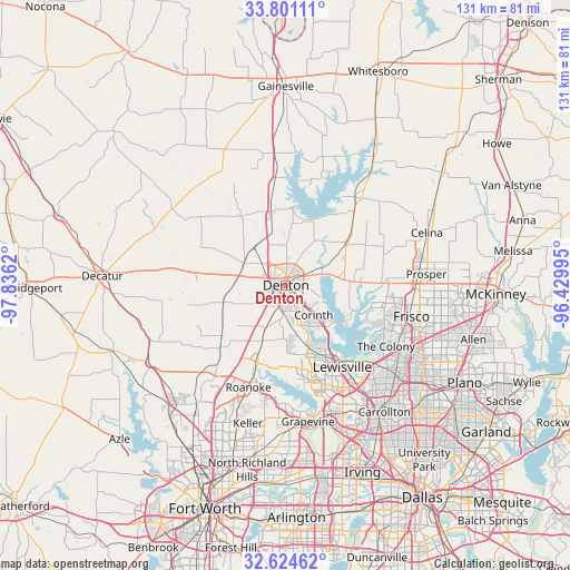
Denton GPS coordinates[2]
33° 12' 53.424" North, 97° 7' 59.052" West
| Map corner | latitude | longitude |
|---|---|---|
| Upper-left | 33.80111°, | -97.8362° |
| Center: | 33.21484°, | -97.13307° |
| Lower-right: | 32.62462°, | -96.42995° |
| Map W x H: | 130.8×130.8 km | = 81.3×81.3mi |
| max Lat: | 71.29058° ⇑84.3% North |
| Denton: | 33.21484° |
| min Lat: | ⇓15.7% South 19.06759° |
| min Long | Denton | max Long |
| -171.73463° | -97.13307° | -66.98998° |
| W 23.9%⇐ | ⇒76.1% E |
Elevation
Elevation of Denton is 206 m = 676 ft, and this is 88.8 m = 291 ft below average elevation for this country.
| Max E: |
3189 m = 10463 ft | 48.1% |
| Avg. | 294.8 m = 967 ft | |
| Denton | 206 m = 676 ft | |
Min E: |
-60 m = -197 ft | 51.9% |
See also: Denton elevation on elevation.city.
Geographical zone
Denton is located in North temperate zone (between Tropic of Cancer and the Arctic Circle). Distance of this Northern Tropic circle is 1087.2 km =675.6 mi to South.| Distance of | km | miles | from Denton |
|---|---|---|---|
| North Pole | 6313.9 | 3923.3 | to North |
| Arctic Circle | 3708 | 2304 | to North |
| Tropic Cancer | 1087.2 | 675.6 | to South |
| Equator | 3693.1 | 2294.8 | to South |


Nearby cities:
15 places around Denton: (largest is in red/bold)
• Argyle
11.4 km =7.1 mi,  204°
204°
• Bartonville
15.8 km =9.8 mi,  179°
179°
• Copper Canyon
13.6 km =8.5 mi,  165°
165°
• Corinth
9.3 km =5.8 mi,  136°
136°
• Cross Roads
12.3 km =7.6 mi,  81°
81°
• Hickory Creek
13.3 km =8.3 mi, 140°
• Krugerville
15.2 km =9.4 mi,  60°
60°
• Krum
11.1 km =6.9 mi,  297°
297°
• Lake Dallas
14.6 km =9.1 mi, 136°
• Lantana
13.8 km =8.6 mi, 176°
• New Hope (historical)
13.6 km =8.5 mi, 80°
• Northlake
15.7 km =9.8 mi,  231°
231°
• Oak Point
13.4 km =8.3 mi,  101°
101°
• Ponder
14.8 km =9.2 mi,  256°
256°
• Shady Shores
11.1 km =6.9 mi,  119°
119°
Sources, notices
• [Note1] Compared only with cities in United States existing in our database
• [Src1] Map data: © OpenStreetMap contributors (CC-BY-SA)
• [Src2] Other city data from geonames.org with taken over terms of usage.
• [Src3] Geographical zone / Annual Mean Temperature by Robert A. Rohde @ Wikipedia
