Doffing geodata
Doffing (Texas) is a populated place; located in United States in America/Chicago (GMT-5) time zone. With population of 5,091 people, there are 7088 cities with bigger population in this country. Compared to other cities in United States, 98.3% of cities are located further ↑North; 79.2% of cities are located further →East and 77.1% of cities have higher elevation than Doffing. Note1


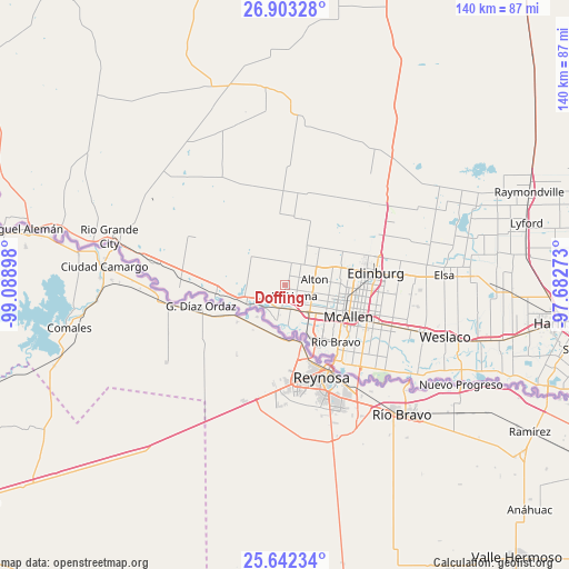
Doffing GPS coordinates[2]
26° 16' 28.272" North, 98° 23' 9.06" West
| Map corner | latitude | longitude |
|---|---|---|
| Upper-left | 26.90328°, | -99.08898° |
| Center: | 26.27452°, | -98.38585° |
| Lower-right: | 25.64234°, | -97.68273° |
| Map W x H: | 140.2×140.2 km | = 87.1×87.1mi |
| max Lat: | 71.29058° ⇑98.3% North |
| Doffing: | 26.27452° |
| min Lat: | ⇓1.7% South 19.06759° |
| min Long | Doffing | max Long |
| -171.73463° | -98.38585° | -66.98998° |
| W 20.8%⇐ | ⇒79.2% E |
Elevation
Elevation of Doffing is 60 m = 197 ft, and this is 234.8 m = 770 ft below average elevation for this country.
| Max E: |
3189 m = 10463 ft | 77.1% |
| Avg. | 294.8 m = 967 ft | |
| Doffing | 60 m = 197 ft | |
Min E: |
-60 m = -197 ft | 22.9% |
See also: United States elevation on elevation.city.
Geographical zone
Doffing is located in North temperate zone (between Tropic of Cancer and the Arctic Circle). Distance of this Northern Tropic circle is 315.5 km =196 mi to South.| Distance of | km | miles | from Doffing |
|---|---|---|---|
| North Pole | 7085.6 | 4402.8 | to North |
| Arctic Circle | 4479.7 | 2783.6 | to North |
| Tropic Cancer | 315.5 | 196 | to South |
| Equator | 2921.5 | 1815.3 | to South |


Nearby cities:
15 places around Doffing: (largest is in red/bold)
• Abram
8.7 km =5.4 mi,  196°
196°
• Alton
7.4 km =4.6 mi,  78°
78°
• Alton North (historical)
8.4 km =5.2 mi,  74°
74°
• Citrus City
5.8 km =3.6 mi,  0°
0°
• La Homa
3.5 km =2.2 mi,  140°
140°
• La Joya
10 km =6.2 mi,  252°
252°
• McAllen
17.4 km =10.8 mi,  116°
116°
• Mission
8.9 km =5.5 mi, 137°
• Palmhurst
7 km =4.3 mi,  104°
104°
• Palmview
4.8 km =3 mi,  161°
161°
• Palmview South
6.6 km =4.1 mi,  173°
173°
• Penitas
7.6 km =4.7 mi,  230°
230°
• Perezville
5.8 km =3.6 mi,  194°
194°
• Sullivan City
17.7 km =11 mi,  271°
271°
• West Sharyland
5.7 km =3.5 mi,  92°
92°
Sources, notices
• [Note1] Compared only with cities in United States existing in our database
• [Src1] Map data: © OpenStreetMap contributors (CC-BY-SA)
• [Src2] Other city data from geonames.org with taken over terms of usage.
• [Src3] Geographical zone / Annual Mean Temperature by Robert A. Rohde @ Wikipedia
