Mission geodata
Mission (Texas) is a populated place; located in United States in America/Chicago (GMT-5) time zone. With population of 83,298 people, there are 468 cities with bigger population in this country. Compared to other cities in United States, 98.5% of cities are located further ↑North; 79.1% of cities are located further →East and 79.9% of cities have higher elevation than Mission. Note1


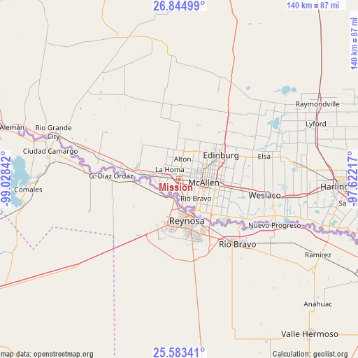
Mission GPS coordinates[2]
26° 12' 57.276" North, 98° 19' 31.044" West
| Map corner | latitude | longitude |
|---|---|---|
| Upper-left | 26.84499°, | -99.02842° |
| Center: | 26.21591°, | -98.32529° |
| Lower-right: | 25.58341°, | -97.62217° |
| Map W x H: | 140.3×140.3 km | = 87.2×87.2mi |
| max Lat: | 71.29058° ⇑98.5% North |
| Mission: | 26.21591° |
| min Lat: | ⇓1.5% South 19.06759° |
| min Long | Mission | max Long |
| -171.73463° | -98.32529° | -66.98998° |
| W 20.9%⇐ | ⇒79.1% E |
Elevation
Elevation of Mission is 47 m = 154 ft, and this is 247.8 m = 813 ft below average elevation for this country.
| Max E: |
3189 m = 10463 ft | 79.9% |
| Avg. | 294.8 m = 967 ft | |
| Mission | 47 m = 154 ft | |
Min E: |
-60 m = -197 ft | 20.1% |
See also: Mission elevation on elevation.city.
Geographical zone
Mission is located in North temperate zone (between Tropic of Cancer and the Arctic Circle). Distance of this Northern Tropic circle is 309 km =192 mi to South.| Distance of | km | miles | from Mission |
|---|---|---|---|
| North Pole | 7092.1 | 4406.8 | to North |
| Arctic Circle | 4486.2 | 2787.6 | to North |
| Tropic Cancer | 309 | 192 | to South |
| Equator | 2914.9 | 1811.2 | to South |


Nearby cities:
15 places around Mission: (largest is in red/bold)
• Abram
8.7 km =5.4 mi,  258°
258°
• Alton
8 km =5 mi,  8°
8°
• Alton North (historical)
9.1 km =5.7 mi, 13°
• Citrus City
13.7 km =8.5 mi,  334°
334°
• Doffing
8.9 km =5.5 mi,  317°
317°
• Hidalgo
14.3 km =8.9 mi,  154°
154°
• La Homa
5.4 km =3.4 mi,  314°
314°
• McAllen
9.6 km =6 mi,  98°
98°
• Palmhurst
4.8 km =3 mi, 8°
• Palmview
4.9 km =3 mi,  293°
293°
• Palmview South
5.3 km =3.3 mi,  269°
269°
• Penitas
12 km =7.5 mi,  277°
277°
• Perezville
7.6 km =4.7 mi, 277°
• Pharr
14.3 km =8.9 mi, 99°
• West Sharyland
6.3 km =3.9 mi,  356°
356°
Sources, notices
• [Note1] Compared only with cities in United States existing in our database
• [Src1] Map data: © OpenStreetMap contributors (CC-BY-SA)
• [Src2] Other city data from geonames.org with taken over terms of usage.
• [Src3] Geographical zone / Annual Mean Temperature by Robert A. Rohde @ Wikipedia
