McAllen geodata
McAllen (Texas) is a populated place; located in United States in America/Chicago (GMT-5) time zone. With population of 140,269 people, there are 215 cities with bigger population in this country. Compared to other cities in United States, 98.5% of cities are located further ↑North; 78.9% of cities are located further →East and 81.1% of cities have higher elevation than McAllen. Note1


McAllen GPS coordinates[2]
26° 12' 12.276" North, 98° 13' 48.036" West
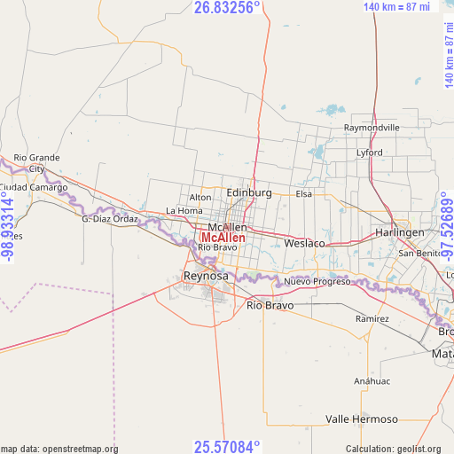
| Map corner | latitude | longitude |
|---|---|---|
| Upper-left | 26.83256°, | -98.93314° |
| Center: | 26.20341°, | -98.23001° |
| Lower-right: | 25.57084°, | -97.52689° |
| Map W x H: | 140.3×140.3 km | = 87.2×87.2mi |
| max Lat: | 71.29058° ⇑98.5% North |
| McAllen: | 26.20341° |
| min Lat: | ⇓1.5% South 19.06759° |
| min Long | McAllen | max Long |
| -171.73463° | -98.23001° | -66.98998° |
| W 21.1%⇐ | ⇒78.9% E |
Elevation
Elevation of McAllen is 42 m = 138 ft, and this is 252.8 m = 829 ft below average elevation for this country.
| Max E: |
3189 m = 10463 ft | 81.1% |
| Avg. | 294.8 m = 967 ft | |
| McAllen | 42 m = 138 ft | |
Min E: |
-60 m = -197 ft | 18.9% |
See also: McAllen elevation on elevation.city.
Geographical zone
McAllen is located in North temperate zone (between Tropic of Cancer and the Arctic Circle). Distance of this Northern Tropic circle is 307.6 km =191.1 mi to South.| Distance of | km | miles | from McAllen |
|---|---|---|---|
| North Pole | 7093.5 | 4407.7 | to North |
| Arctic Circle | 4487.6 | 2788.5 | to North |
| Tropic Cancer | 307.6 | 191.1 | to South |
| Equator | 2913.5 | 1810.4 | to South |


Nearby cities:
15 places around McAllen: (largest is in red/bold)
• Alamo
10.9 km =6.8 mi,  101°
101°
• Alton
12.5 km =7.8 mi,  318°
318°
• Alton North (historical)
12.6 km =7.8 mi, 324°
• Edinburg
12.8 km =8 mi,  31°
31°
• Hidalgo
11.9 km =7.4 mi,  196°
196°
• Lopezville
8 km =5 mi,  61°
61°
• Mission
9.6 km =6 mi,  278°
278°
• Murillo Colonia
13 km =8.1 mi, 63°
• North Alamo
10.2 km =6.3 mi,  81°
81°
• Nurillo
12.9 km =8 mi, 56°
• Palmhurst
10.7 km =6.6 mi,  304°
304°
• Pharr
4.7 km =2.9 mi, 101°
• San Juan
7.6 km =4.7 mi, 101°
• South Alamo
13.2 km =8.2 mi,  113°
113°
• West Sharyland
12.5 km =7.8 mi,  308°
308°
Sources, notices
• [Note1] Compared only with cities in United States existing in our database
• [Src1] Map data: © OpenStreetMap contributors (CC-BY-SA)
• [Src2] Other city data from geonames.org with taken over terms of usage.
• [Src3] Geographical zone / Annual Mean Temperature by Robert A. Rohde @ Wikipedia
