Bulverde geodata
Bulverde (Texas) is a populated place; located in United States in America/Chicago (GMT-5) time zone. With population of 4,925 people, there are 7257 cities with bigger population in this country. Compared to other cities in United States, 94% of cities are located further ↑North; 79.3% of cities are located further →East and 78.6% of cities have lower elevation than Bulverde. Note1


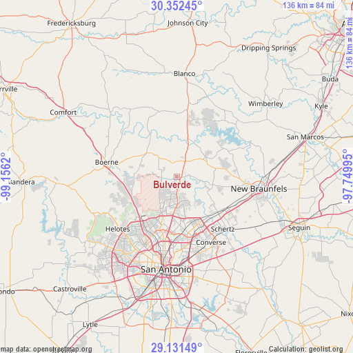
Bulverde GPS coordinates[2]
29° 44' 37.788" North, 98° 27' 11.052" West
| Map corner | latitude | longitude |
|---|---|---|
| Upper-left | 30.35245°, | -99.1562° |
| Center: | 29.74383°, | -98.45307° |
| Lower-right: | 29.13149°, | -97.74995° |
| Map W x H: | 135.8×135.8 km | = 84.4×84.4mi |
| max Lat: | 71.29058° ⇑94% North |
| Bulverde: | 29.74383° |
| min Lat: | ⇓6% South 19.06759° |
| min Long | Bulverde | max Long |
| -171.73463° | -98.45307° | -66.98998° |
| W 20.7%⇐ | ⇒79.3% E |
Elevation
Elevation of Bulverde is 341 m = 1119 ft, and this is 46.2 m = 152 ft above average elevation for this country.
| Max E: |
3189 m = 10463 ft | 21.4% |
| Bulverde | 341 m 1119 ft | |
| Avg. | 294.8 m = 967 ft | |
Min E: |
-60 m = -197 ft | 78.6% |
See also: United States elevation on elevation.city.
Geographical zone
Bulverde is located in North temperate zone (between Tropic of Cancer and the Arctic Circle). Distance of this Northern Tropic circle is 701.3 km =435.8 mi to South.| Distance of | km | miles | from Bulverde |
|---|---|---|---|
| North Pole | 6699.9 | 4163.1 | to North |
| Arctic Circle | 4094 | 2543.9 | to North |
| Tropic Cancer | 701.3 | 435.8 | to South |
| Equator | 3307.2 | 2055 | to South |


Nearby cities:
15 places around Bulverde: (largest is in red/bold)
• Canyon Lake
23.5 km =14.6 mi,  51°
51°
• Castle Hills
25.3 km =15.7 mi,  194°
194°
• Cross Mountain
22.7 km =14.1 mi,  241°
241°
• Fair Oaks Ranch
18.4 km =11.4 mi,  270°
270°
• Garden Ridge
18.7 km =11.6 mi,  130°
130°
• Grey Forest
26.2 km =16.3 mi, 237°
• Hill Country Village
18.3 km =11.4 mi, 191°
• Hollywood Park
16.3 km =10.1 mi, 191°
• Live Oak
22.8 km =14.2 mi,  150°
150°
• Northcliff
25.9 km =16.1 mi,  121°
121°
• Scenic Oaks
21.8 km =13.5 mi,  260°
260°
• Selma
22.7 km =14.1 mi,  141°
141°
• Shavano Park
20.1 km =12.5 mi,  208°
208°
• Timberwood Park
4.9 km =3 mi, 209°
• Windcrest
26.3 km =16.3 mi,  164°
164°
Sources, notices
• [Note1] Compared only with cities in United States existing in our database
• [Src1] Map data: © OpenStreetMap contributors (CC-BY-SA)
• [Src2] Other city data from geonames.org with taken over terms of usage.
• [Src3] Geographical zone / Annual Mean Temperature by Robert A. Rohde @ Wikipedia
