Italy geodata
Italy (Texas) is a populated place; located in United States in America/Chicago (GMT-5) time zone. With population of 1,897 people, there are 12237 cities with bigger population in this country. Compared to other cities in United States, 88.1% of cities are located further ↑North; 75.4% of cities are located further →East and 56.2% of cities have higher elevation than Italy. Note1


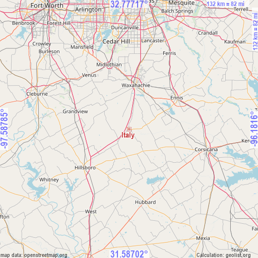
Italy GPS coordinates[2]
32° 11' 2.544" North, 96° 53' 4.992" West
| Map corner | latitude | longitude |
|---|---|---|
| Upper-left | 32.77717°, | -97.58785° |
| Center: | 32.18404°, | -96.88472° |
| Lower-right: | 31.58702°, | -96.1816° |
| Map W x H: | 132.3×132.3 km | = 82.2×82.2mi |
| max Lat: | 71.29058° ⇑88.1% North |
| Italy: | 32.18404° |
| min Lat: | ⇓11.9% South 19.06759° |
| min Long | Italy | max Long |
| -171.73463° | -96.88472° | -66.98998° |
| W 24.6%⇐ | ⇒75.4% E |
Elevation
Elevation of Italy is 175 m = 574 ft, and this is 119.8 m = 393 ft below average elevation for this country.
| Max E: |
3189 m = 10463 ft | 56.2% |
| Avg. | 294.8 m = 967 ft | |
| Italy | 175 m = 574 ft | |
Min E: |
-60 m = -197 ft | 43.8% |
See also: United States elevation on elevation.city.
Geographical zone
Italy is located in North temperate zone (between Tropic of Cancer and the Arctic Circle). Distance of this Northern Tropic circle is 972.6 km =604.3 mi to South.| Distance of | km | miles | from Italy |
|---|---|---|---|
| North Pole | 6428.5 | 3994.5 | to North |
| Arctic Circle | 3822.6 | 2375.3 | to North |
| Tropic Cancer | 972.6 | 604.3 | to South |
| Equator | 3578.5 | 2223.6 | to South |


Nearby cities:
15 places around Italy: (largest is in red/bold)
• Bardwell
20.1 km =12.5 mi,  61°
61°
• Blooming Grove
18.9 km =11.7 mi,  122°
122°
• Ennis
29.3 km =18.2 mi, 56°
• Frost
13.7 km =8.5 mi,  147°
147°
• Garrett
29.4 km =18.3 mi,  47°
47°
• Grandview
29.3 km =18.2 mi,  289°
289°
• Hillsboro
30.1 km =18.7 mi,  230°
230°
• Itasca
25.1 km =15.6 mi,  263°
263°
• Maypearl
18.7 km =11.6 mi,  320°
320°
• Milford
8.7 km =5.4 mi,  220°
220°
• Nash
11.3 km =7 mi,  36°
36°
• Palmer
34.2 km =21.3 mi, 36°
• Plum Grove
9.9 km =6.2 mi,  277°
277°
• Rankin
16.9 km =10.5 mi,  81°
81°
• Waxahachie
22.8 km =14.2 mi,  8°
8°
Sources, notices
• [Note1] Compared only with cities in United States existing in our database
• [Src1] Map data: © OpenStreetMap contributors (CC-BY-SA)
• [Src2] Other city data from geonames.org with taken over terms of usage.
• [Src3] Geographical zone / Annual Mean Temperature by Robert A. Rohde @ Wikipedia
