Maypearl geodata
Maypearl (Texas) is a populated place; located in United States in America/Chicago (GMT-5) time zone. With population of 981 people, there are 16400 cities with bigger population in this country. Compared to other cities in United States, 87.8% of cities are located further ↑North; 75.7% of cities are located further →East and 58.2% of cities have higher elevation than Maypearl. Note1


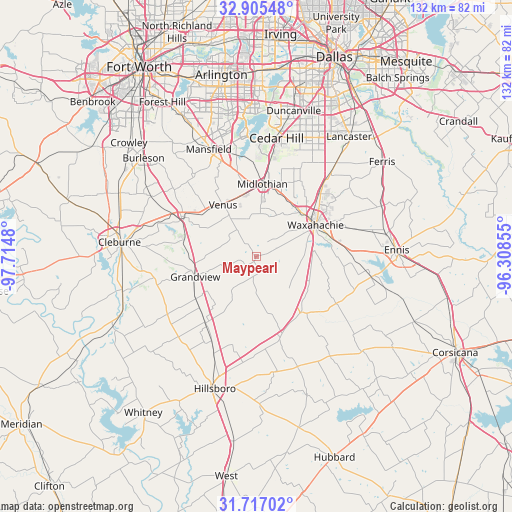
Maypearl GPS coordinates[2]
32° 18' 47.52" North, 97° 0' 42.012" West
| Map corner | latitude | longitude |
|---|---|---|
| Upper-left | 32.90548°, | -97.7148° |
| Center: | 32.3132°, | -97.01167° |
| Lower-right: | 31.71702°, | -96.30855° |
| Map W x H: | 132.1×132.1 km | = 82.1×82.1mi |
| max Lat: | 71.29058° ⇑87.8% North |
| Maypearl: | 32.3132° |
| min Lat: | ⇓12.2% South 19.06759° |
| min Long | Maypearl | max Long |
| -171.73463° | -97.01167° | -66.98998° |
| W 24.3%⇐ | ⇒75.7% E |
Elevation
Elevation of Maypearl is 164 m = 538 ft, and this is 130.8 m = 429 ft below average elevation for this country.
| Max E: |
3189 m = 10463 ft | 58.2% |
| Avg. | 294.8 m = 967 ft | |
| Maypearl | 164 m = 538 ft | |
Min E: |
-60 m = -197 ft | 41.8% |
See also: United States elevation on elevation.city.
Geographical zone
Maypearl is located in North temperate zone (between Tropic of Cancer and the Arctic Circle). Distance of this Northern Tropic circle is 987 km =613.3 mi to South.| Distance of | km | miles | from Maypearl |
|---|---|---|---|
| North Pole | 6414.2 | 3985.6 | to North |
| Arctic Circle | 3808.3 | 2366.4 | to North |
| Tropic Cancer | 987 | 613.3 | to South |
| Equator | 3592.9 | 2232.5 | to South |


Nearby cities:
15 places around Maypearl: (largest is in red/bold)
• Alvarado
21.5 km =13.4 mi,  298°
298°
• Glenn Heights
30 km =18.6 mi,  29°
29°
• Grandview
16.4 km =10.2 mi,  253°
253°
• Italy
18.7 km =11.6 mi,  140°
140°
• Itasca
21.5 km =13.4 mi,  217°
217°
• Midlothian
18.9 km =11.7 mi,  4°
4°
• Milford
21.9 km =13.6 mi,  163°
163°
• Nash
19.4 km =12.1 mi,  105°
105°
• Oak Leaf
27.3 km =17 mi, 32°
• Ovilla
26.5 km =16.5 mi, 26°
• Pecan Hill
28.7 km =17.8 mi,  47°
47°
• Plum Grove
13.2 km =8.2 mi,  170°
170°
• Red Oak
29.9 km =18.6 mi,  40°
40°
• Venus
15.9 km =9.9 mi,  327°
327°
• Waxahachie
17.4 km =10.8 mi,  62°
62°
Sources, notices
• [Note1] Compared only with cities in United States existing in our database
• [Src1] Map data: © OpenStreetMap contributors (CC-BY-SA)
• [Src2] Other city data from geonames.org with taken over terms of usage.
• [Src3] Geographical zone / Annual Mean Temperature by Robert A. Rohde @ Wikipedia
