Leander geodata
Leander (Texas) is a populated place; located in United States in America/Chicago (GMT-5) time zone. With population of 37,889 people, there are 1283 cities with bigger population in this country. Compared to other cities in United States, 91.6% of cities are located further ↑North; 78.1% of cities are located further →East and 72.9% of cities have lower elevation than Leander. Note1


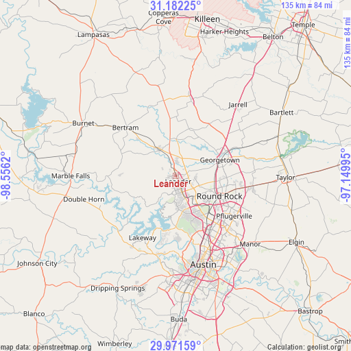
Leander GPS coordinates[2]
30° 34' 43.716" North, 97° 51' 11.052" West
| Map corner | latitude | longitude |
|---|---|---|
| Upper-left | 31.18225°, | -98.5562° |
| Center: | 30.57881°, | -97.85307° |
| Lower-right: | 29.97159°, | -97.14995° |
| Map W x H: | 134.6×134.6 km | = 83.6×83.6mi |
| max Lat: | 71.29058° ⇑91.6% North |
| Leander: | 30.57881° |
| min Lat: | ⇓8.4% South 19.06759° |
| min Long | Leander | max Long |
| -171.73463° | -97.85307° | -66.98998° |
| W 21.9%⇐ | ⇒78.1% E |
Elevation
Elevation of Leander is 301 m = 988 ft, and this is 6.2 m = 20 ft above average elevation for this country.
| Max E: |
3189 m = 10463 ft | 27.1% |
| Leander | 301 m 988 ft | |
| Avg. | 294.8 m = 967 ft | |
Min E: |
-60 m = -197 ft | 72.9% |
See also: United States elevation on elevation.city.
Geographical zone
Leander is located in North temperate zone (between Tropic of Cancer and the Arctic Circle). Distance of this Northern Tropic circle is 794.1 km =493.4 mi to South.| Distance of | km | miles | from Leander |
|---|---|---|---|
| North Pole | 6607 | 4105.4 | to North |
| Arctic Circle | 4001.1 | 2486.2 | to North |
| Tropic Cancer | 794.1 | 493.4 | to South |
| Equator | 3400 | 2112.7 | to South |


Nearby cities:
15 places around Leander: (largest is in red/bold)
• Anderson Mill
14.5 km =9 mi,  161°
161°
• Brushy Creek
13.1 km =8.1 mi,  123°
123°
• Cedar Park
8.8 km =5.5 mi, 159°
• Georgetown
17.9 km =11.1 mi,  70°
70°
• Hudson Bend
19.4 km =12.1 mi,  202°
202°
• Jollyville
16.9 km =10.5 mi,  153°
153°
• Jonestown
11.5 km =7.1 mi,  215°
215°
• Lago Vista
18.5 km =11.5 mi, 224°
• Liberty Hill
11.7 km =7.3 mi,  325°
325°
• Point Venture
26.1 km =16.2 mi,  211°
211°
• Round Rock
18.4 km =11.4 mi, 115°
• Serenada
20.4 km =12.7 mi,  48°
48°
• Volente
16.8 km =10.4 mi, 196°
• Wells Branch
22.2 km =13.8 mi,  131°
131°
• Windemere
23.6 km =14.7 mi, 124°
Sources, notices
• [Note1] Compared only with cities in United States existing in our database
• [Src1] Map data: © OpenStreetMap contributors (CC-BY-SA)
• [Src2] Other city data from geonames.org with taken over terms of usage.
• [Src3] Geographical zone / Annual Mean Temperature by Robert A. Rohde @ Wikipedia
