Wells Branch geodata
Wells Branch (Texas) is a populated place; located in United States in America/Chicago (GMT-5) time zone. With population of 12,120 people, there are 3870 cities with bigger population in this country. Compared to other cities in United States, 92% of cities are located further ↑North; 77.7% of cities are located further →East and 63.7% of cities have lower elevation than Wells Branch. Note1


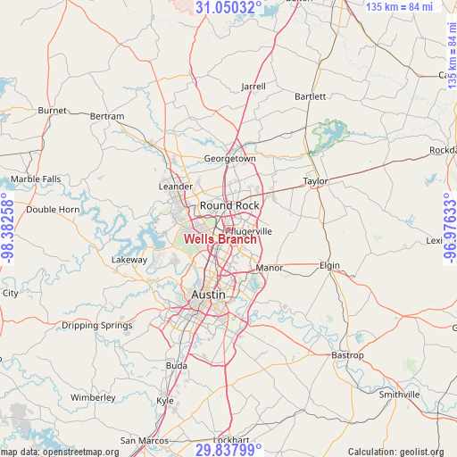
Wells Branch GPS coordinates[2]
30° 26' 45.744" North, 97° 40' 46.02" West
| Map corner | latitude | longitude |
|---|---|---|
| Upper-left | 31.05032°, | -98.38258° |
| Center: | 30.44604°, | -97.67945° |
| Lower-right: | 29.83799°, | -96.97633° |
| Map W x H: | 134.8×134.8 km | = 83.8×83.8mi |
| max Lat: | 71.29058° ⇑92% North |
| Wells Branch: | 30.44604° |
| min Lat: | ⇓8% South 19.06759° |
| min Long | Wells Branch | max Long |
| -171.73463° | -97.67945° | -66.98998° |
| W 22.3%⇐ | ⇒77.7% E |
Elevation
Elevation of Wells Branch is 256 m = 840 ft, and this is 38.8 m = 127 ft below average elevation for this country.
| Max E: |
3189 m = 10463 ft | 36.3% |
| Avg. | 294.8 m = 967 ft | |
| Wells Branch | 256 m = 840 ft | |
Min E: |
-60 m = -197 ft | 63.7% |
See also: United States elevation on elevation.city.
Geographical zone
Wells Branch is located in North temperate zone (between Tropic of Cancer and the Arctic Circle). Distance of this Northern Tropic circle is 779.4 km =484.3 mi to South.| Distance of | km | miles | from Wells Branch |
|---|---|---|---|
| North Pole | 6621.8 | 4114.6 | to North |
| Arctic Circle | 4015.9 | 2495.4 | to North |
| Tropic Cancer | 779.4 | 484.3 | to South |
| Equator | 3385.3 | 2103.5 | to South |


Nearby cities:
15 places around Wells Branch: (largest is in red/bold)
• Anderson Mill
12.2 km =7.6 mi,  274°
274°
• Austin
20.8 km =12.9 mi,  197°
197°
• Brushy Creek
9.5 km =5.9 mi,  322°
322°
• Cedar Park
15 km =9.3 mi,  295°
295°
• Georgetown
20.8 km =12.9 mi,  0°
0°
• Hutto
16.7 km =10.4 mi,  49°
49°
• Jollyville
9.2 km =5.7 mi, 267°
• Leander
22.2 km =13.8 mi,  311°
311°
• Manor
16.6 km =10.3 mi,  134°
134°
• Pflugerville
5.7 km =3.5 mi,  97°
97°
• Rollingwood
21.6 km =13.4 mi,  209°
209°
• Round Rock
6.9 km =4.3 mi, 0°
• Volente
21.5 km =13.4 mi, 266°
• West Lake Hills
20.2 km =12.6 mi,  215°
215°
• Windemere
3.2 km =2 mi,  63°
63°
Sources, notices
• [Note1] Compared only with cities in United States existing in our database
• [Src1] Map data: © OpenStreetMap contributors (CC-BY-SA)
• [Src2] Other city data from geonames.org with taken over terms of usage.
• [Src3] Geographical zone / Annual Mean Temperature by Robert A. Rohde @ Wikipedia
