Georgetown geodata
Georgetown (Texas) is a seat of a second-order administrative division; located in United States in America/Chicago (GMT-5) time zone. With population of 63,716 people, there are 680 cities with bigger population in this country. Compared to other cities in United States, 91.4% of cities are located further ↑North; 77.7% of cities are located further →East and 59% of cities have lower elevation than Georgetown. Note1


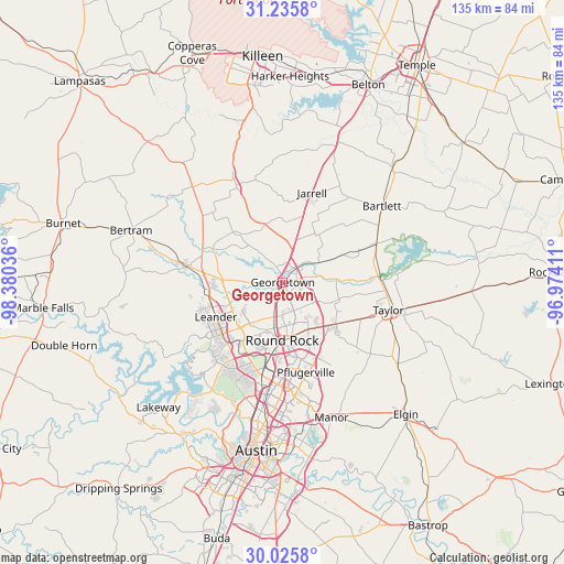
Georgetown GPS coordinates[2]
30° 37' 57.684" North, 97° 40' 38.028" West
| Map corner | latitude | longitude |
|---|---|---|
| Upper-left | 31.2358°, | -98.38036° |
| Center: | 30.63269°, | -97.67723° |
| Lower-right: | 30.0258°, | -96.97411° |
| Map W x H: | 134.5×134.5 km | = 83.6×83.6mi |
| max Lat: | 71.29058° ⇑91.4% North |
| Georgetown: | 30.63269° |
| min Lat: | ⇓8.6% South 19.06759° |
| min Long | Georgetown | max Long |
| -171.73463° | -97.67723° | -66.98998° |
| W 22.3%⇐ | ⇒77.7% E |
Elevation
Elevation of Georgetown is 235 m = 771 ft, and this is 59.8 m = 196 ft below average elevation for this country.
| Max E: |
3189 m = 10463 ft | 41% |
| Avg. | 294.8 m = 967 ft | |
| Georgetown | 235 m = 771 ft | |
Min E: |
-60 m = -197 ft | 59% |
See also: Georgetown elevation on elevation.city.
Geographical zone
Georgetown is located in North temperate zone (between Tropic of Cancer and the Arctic Circle). Distance of this Northern Tropic circle is 800.1 km =497.2 mi to South.| Distance of | km | miles | from Georgetown |
|---|---|---|---|
| North Pole | 6601 | 4101.7 | to North |
| Arctic Circle | 3995.1 | 2482.4 | to North |
| Tropic Cancer | 800.1 | 497.2 | to South |
| Equator | 3406 | 2116.4 | to South |


Nearby cities:
15 places around Georgetown: (largest is in red/bold)
• Anderson Mill
23.3 km =14.5 mi,  211°
211°
• Brushy Creek
14.5 km =9 mi,  204°
204°
• Cedar Park
19.7 km =12.2 mi,  224°
224°
• Florence
25.7 km =16 mi,  334°
334°
• Granger
24.3 km =15.1 mi,  67°
67°
• Hutto
16 km =9.9 mi,  128°
128°
• Jarrell
22.5 km =14 mi,  18°
18°
• Jollyville
23.1 km =14.4 mi, 203°
• Leander
17.9 km =11.1 mi,  250°
250°
• Liberty Hill
23.7 km =14.7 mi,  278°
278°
• Pflugerville
22.2 km =13.8 mi,  165°
165°
• Round Rock
13.8 km =8.6 mi,  180°
180°
• Serenada
7.5 km =4.7 mi,  349°
349°
• Wells Branch
20.8 km =12.9 mi, 180°
• Windemere
19.5 km =12.1 mi, 172°
Sources, notices
• [Note1] Compared only with cities in United States existing in our database
• [Src1] Map data: © OpenStreetMap contributors (CC-BY-SA)
• [Src2] Other city data from geonames.org with taken over terms of usage.
• [Src3] Geographical zone / Annual Mean Temperature by Robert A. Rohde @ Wikipedia
