Leming geodata
Leming (Texas) is a populated place; located in United States in America/Chicago (GMT-5) time zone. With population of 946 people, there are 16667 cities with bigger population in this country. Compared to other cities in United States, 95.1% of cities are located further ↑North; 79.3% of cities are located further →East and 61.5% of cities have higher elevation than Leming. Note1


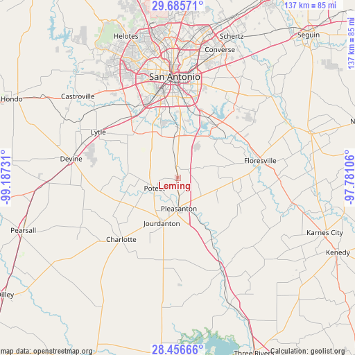
Leming GPS coordinates[2]
29° 4' 22.872" North, 98° 29' 3.048" West
| Map corner | latitude | longitude |
|---|---|---|
| Upper-left | 29.68571°, | -99.18731° |
| Center: | 29.07302°, | -98.48418° |
| Lower-right: | 28.45666°, | -97.78106° |
| Map W x H: | 136.7×136.7 km | = 84.9×84.9mi |
| max Lat: | 71.29058° ⇑95.1% North |
| Leming: | 29.07302° |
| min Lat: | ⇓4.9% South 19.06759° |
| min Long | Leming | max Long |
| -171.73463° | -98.48418° | -66.98998° |
| W 20.7%⇐ | ⇒79.3% E |
Elevation
Elevation of Leming is 147 m = 482 ft, and this is 147.8 m = 485 ft below average elevation for this country.
| Max E: |
3189 m = 10463 ft | 61.5% |
| Avg. | 294.8 m = 967 ft | |
| Leming | 147 m = 482 ft | |
Min E: |
-60 m = -197 ft | 38.5% |
See also: United States elevation on elevation.city.
Geographical zone
Leming is located in North temperate zone (between Tropic of Cancer and the Arctic Circle). Distance of this Northern Tropic circle is 626.7 km =389.4 mi to South.| Distance of | km | miles | from Leming |
|---|---|---|---|
| North Pole | 6774.4 | 4209.4 | to North |
| Arctic Circle | 4168.6 | 2590.2 | to North |
| Tropic Cancer | 626.7 | 389.4 | to South |
| Equator | 3232.6 | 2008.6 | to South |


Nearby cities:
15 places around Leming: (largest is in red/bold)
• Charlotte
31.9 km =19.8 mi,  222°
222°
• China Grove
37.5 km =23.3 mi,  20°
20°
• Elmendorf
25.1 km =15.6 mi,  35°
35°
• Floresville
32.6 km =20.3 mi,  78°
78°
• Jourdanton
18.3 km =11.4 mi,  199°
199°
• Lackland Air Force Base
37.2 km =23.1 mi,  339°
339°
• Lytle
35.2 km =21.9 mi,  300°
300°
• Macdona
34.5 km =21.4 mi,  324°
324°
• Natalia
39 km =24.2 mi,  289°
289°
• Pleasanton
11.8 km =7.3 mi,  177°
177°
• Poteet
8.9 km =5.5 mi,  246°
246°
• Poth
39.1 km =24.3 mi,  90°
90°
• San Antonio
39 km =24.2 mi,  358°
358°
• Somerset
24 km =14.9 mi, 315°
• Von Ormy
28.6 km =17.8 mi,  327°
327°
Sources, notices
• [Note1] Compared only with cities in United States existing in our database
• [Src1] Map data: © OpenStreetMap contributors (CC-BY-SA)
• [Src2] Other city data from geonames.org with taken over terms of usage.
• [Src3] Geographical zone / Annual Mean Temperature by Robert A. Rohde @ Wikipedia
