Jourdanton geodata
Jourdanton (Texas) is a seat of a second-order administrative division; located in United States in America/Chicago (GMT-5) time zone. With population of 4,275 people, there are 7893 cities with bigger population in this country. Compared to other cities in United States, 95.3% of cities are located further ↑North; 79.4% of cities are located further →East and 62.2% of cities have higher elevation than Jourdanton. Note1


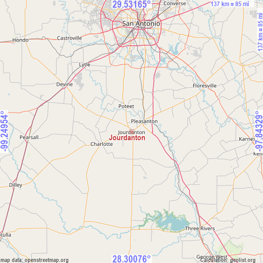
Jourdanton GPS coordinates[2]
28° 55' 4.908" North, 98° 32' 47.076" West
| Map corner | latitude | longitude |
|---|---|---|
| Upper-left | 29.53165°, | -99.24954° |
| Center: | 28.91803°, | -98.54641° |
| Lower-right: | 28.30076°, | -97.84329° |
| Map W x H: | 136.9×136.9 km | = 85.1×85.1mi |
| max Lat: | 71.29058° ⇑95.3% North |
| Jourdanton: | 28.91803° |
| min Lat: | ⇓4.7% South 19.06759° |
| min Long | Jourdanton | max Long |
| -171.73463° | -98.54641° | -66.98998° |
| W 20.6%⇐ | ⇒79.4% E |
Elevation
Elevation of Jourdanton is 143 m = 469 ft, and this is 151.8 m = 498 ft below average elevation for this country.
| Max E: |
3189 m = 10463 ft | 62.2% |
| Avg. | 294.8 m = 967 ft | |
| Jourdanton | 143 m = 469 ft | |
Min E: |
-60 m = -197 ft | 37.8% |
See also: United States elevation on elevation.city.
Geographical zone
Jourdanton is located in North temperate zone (between Tropic of Cancer and the Arctic Circle). Distance of this Northern Tropic circle is 609.5 km =378.7 mi to South.| Distance of | km | miles | from Jourdanton |
|---|---|---|---|
| North Pole | 6791.7 | 4220.2 | to North |
| Arctic Circle | 4185.8 | 2600.9 | to North |
| Tropic Cancer | 609.5 | 378.7 | to South |
| Equator | 3215.4 | 1998 | to South |


Nearby cities:
15 places around Jourdanton: (largest is in red/bold)
• Charlotte
16.8 km =10.4 mi,  248°
248°
• Devine
42.7 km =26.5 mi,  305°
305°
• Elmendorf
42.9 km =26.7 mi,  28°
28°
• Floresville
44.9 km =27.9 mi,  57°
57°
• La Coste
50.6 km =31.4 mi,  329°
329°
• Leming
18.3 km =11.4 mi,  19°
19°
• Lytle
42.6 km =26.5 mi, 325°
• Macdona
47.5 km =29.5 mi,  342°
342°
• Natalia
43.1 km =26.8 mi, 314°
• Pleasanton
8.6 km =5.3 mi,  50°
50°
• Poteet
13.8 km =8.6 mi,  351°
351°
• Poth
48.2 km =30 mi,  69°
69°
• Somerset
36 km =22.4 mi, 342°
• Tilden
50.7 km =31.5 mi,  180°
180°
• Von Ormy
42.3 km =26.3 mi, 347°
Sources, notices
• [Note1] Compared only with cities in United States existing in our database
• [Src1] Map data: © OpenStreetMap contributors (CC-BY-SA)
• [Src2] Other city data from geonames.org with taken over terms of usage.
• [Src3] Geographical zone / Annual Mean Temperature by Robert A. Rohde @ Wikipedia
