Floresville geodata
Floresville (Texas) is a seat of a second-order administrative division; located in United States in America/Chicago (GMT-5) time zone. With population of 7,321 people, there are 5636 cities with bigger population in this country. Compared to other cities in United States, 95.1% of cities are located further ↑North; 78.8% of cities are located further →East and 65.8% of cities have higher elevation than Floresville. Note1


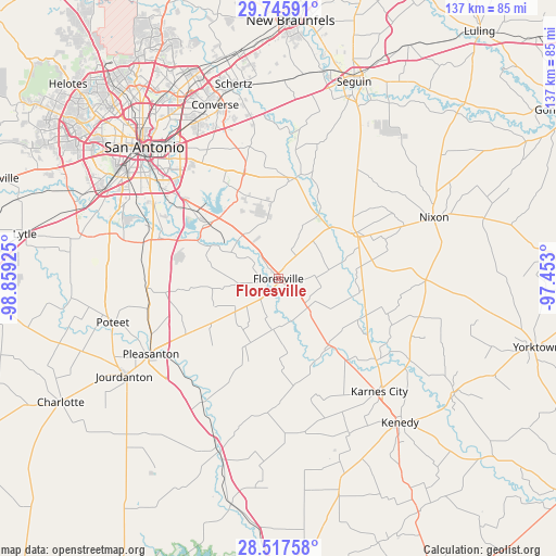
Floresville GPS coordinates[2]
29° 8' 0.888" North, 98° 9' 22.032" West
| Map corner | latitude | longitude |
|---|---|---|
| Upper-left | 29.74591°, | -98.85925° |
| Center: | 29.13358°, | -98.15612° |
| Lower-right: | 28.51758°, | -97.453° |
| Map W x H: | 136.6×136.6 km | = 84.9×84.9mi |
| max Lat: | 71.29058° ⇑95.1% North |
| Floresville: | 29.13358° |
| min Lat: | ⇓4.9% South 19.06759° |
| min Long | Floresville | max Long |
| -171.73463° | -98.15612° | -66.98998° |
| W 21.2%⇐ | ⇒78.8% E |
Elevation
Elevation of Floresville is 124 m = 407 ft, and this is 170.8 m = 560 ft below average elevation for this country.
| Max E: |
3189 m = 10463 ft | 65.8% |
| Avg. | 294.8 m = 967 ft | |
| Floresville | 124 m = 407 ft | |
Min E: |
-60 m = -197 ft | 34.2% |
See also: United States elevation on elevation.city.
Geographical zone
Floresville is located in North temperate zone (between Tropic of Cancer and the Arctic Circle). Distance of this Northern Tropic circle is 633.4 km =393.6 mi to South.| Distance of | km | miles | from Floresville |
|---|---|---|---|
| North Pole | 6767.7 | 4205.3 | to North |
| Arctic Circle | 4161.8 | 2586 | to North |
| Tropic Cancer | 633.4 | 393.6 | to South |
| Equator | 3239.4 | 2012.9 | to South |


Nearby cities:
15 places around Floresville: (largest is in red/bold)
• China Grove
34 km =21.1 mi,  326°
326°
• Elmendorf
21.9 km =13.6 mi,  308°
308°
• Falls City
21.5 km =13.4 mi,  141°
141°
• Karnes City
37.2 km =23.1 mi, 138°
• Kirby
42.9 km =26.7 mi, 328°
• La Vernia
25.1 km =15.6 mi,  9°
9°
• Leming
32.6 km =20.3 mi,  258°
258°
• New Berlin
37.1 km =23.1 mi, 8°
• Nixon
40.8 km =25.4 mi,  68°
68°
• Pleasanton
36.4 km =22.6 mi,  239°
239°
• Poteet
41.3 km =25.7 mi, 255°
• Poth
10.1 km =6.3 mi,  134°
134°
• Saint Hedwig
31.5 km =19.6 mi,  352°
352°
• Santa Clara
42.2 km =26.2 mi,  4°
4°
• Stockdale
22.2 km =13.8 mi,  58°
58°
Sources, notices
• [Note1] Compared only with cities in United States existing in our database
• [Src1] Map data: © OpenStreetMap contributors (CC-BY-SA)
• [Src2] Other city data from geonames.org with taken over terms of usage.
• [Src3] Geographical zone / Annual Mean Temperature by Robert A. Rohde @ Wikipedia
